IMAGES TAKEN NEAR TO
Amy Lane, CHESHAM, HP5 1NA
Introduction
This page details the photographs taken nearby to Amy Lane, HP5 1NA by members of the Geograph project.
The Geograph project started in 2005 with the aim of publishing, organising and preserving representative images for every square kilometre of Great Britain, Ireland and the Isle of Man.

There are currently over 7.5m images from over14,400 individuals and you can help contribute to the project by visiting https://www.geograph.org.uk
Image Map
Images are licensed for reuse under creativecommons.org/licenses/by-sa/2.0
Notes
- Clicking on the map will re-center to the selected point.
- The higher the marker number, the further away the image location is from the centre of the postcode.
Image Listing (175 Images Found)
Images are licensed for reuse under creativecommons.org/licenses/by-sa/2.0
Image
Details
Distance
1
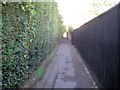
Chesham: New Footpath
This alleyway connects Amy Lane and Germain Street and is actually called New Footpath. It has however long since ceased being new as its route is clearly shown on the Ordnance Survey map of 1898, and arguably on the map of 1878 too.
Image: © Nigel Cox
Taken: 13 Sep 2018
0.02 miles
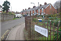
2
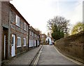
King Street, Chesham
Seen from the Amy Lane end. Mostly flint-built cottages, of various dates.
Results of some preliminary research into the origins of my mother's family suggest that 180 years ago ancestors of ours lived nearby in Amy Lane - where almost nothing remains of the townscape they would have known. Their name was Rance.
Image: © Stefan Czapski
Taken: 30 Mar 2012
0.05 miles
3
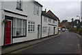
Germain Street, Chesham
Germain Street seen from the junction with King Street.
Image: © Stephen McKay
Taken: 2 Dec 2013
0.06 miles
4
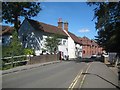
Chesham: Town Bridge
Town Bridge takes Germain Street over the River Chess. The two white cottages on the left of the road beyond the bridge are both Grade II Listed Buildings.
Image: © Nigel Cox
Taken: 13 Sep 2018
0.08 miles
5
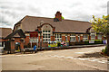
Chesham : Thomas Harding Junior School
"Born c. 1470, Harding lived in Amersham and then Chesham, where he was a farmer. He was a member of the Lollard community and believed in the right to read the scriptures in English. As a result of his unconventional beliefs he was found guilty of heresy and sentenced to be burnt to death at a place now known as Martyr’s Dell on White Hill. Harding was, however, spared a fiery death. As the fire was being lit, someone in the crowd threw a piece of firewood which hit him on the head and killed him instantly." - https://www.chesham.gov.uk/Open_Spaces/Martyr_Stone.aspx
Image: © Jim Osley
Taken: 12 May 2022
0.08 miles
6
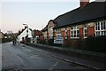
Fullers Hill, Chesham
Thomas Harding Junior School is on the right.
Image: © David Howard
Taken: 24 Dec 2022
0.08 miles
7
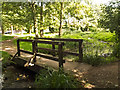
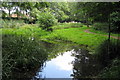
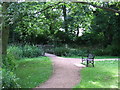
Meades Water Gardens
This section of the River Chess was restored in 2007, as nearby information board explains. There is a walk alongside the river.
Image: © Tom Presland
Taken: 14 Aug 2012
0.09 miles
8
Wey Lane, Chesham
Wey Lane seen from its junction with Germain Street with allotment gardens on the right.
Image: © Stephen McKay
Taken: 2 Dec 2013
0.09 miles
9
Path through woodland, Chesham
A path through woodland in Chesham, Buckinghamshire.
Image: © Malc McDonald
Taken: 4 Jun 2011
0.09 miles