IMAGES TAKEN NEAR TO
East Street, CHESHAM, HP5 1HQ
Introduction
This page details the photographs taken nearby to East Street, HP5 1HQ by members of the Geograph project.
The Geograph project started in 2005 with the aim of publishing, organising and preserving representative images for every square kilometre of Great Britain, Ireland and the Isle of Man.

There are currently over 7.5m images from over14,400 individuals and you can help contribute to the project by visiting https://www.geograph.org.uk
Image Map
Images are licensed for reuse under creativecommons.org/licenses/by-sa/2.0
Notes
- Clicking on the map will re-center to the selected point.
- The higher the marker number, the further away the image location is from the centre of the postcode.
Image Listing (259 Images Found)
Images are licensed for reuse under creativecommons.org/licenses/by-sa/2.0
Image
Details
Distance
1
Chesham: Disused chapel, Red Lion Street
The former Zion Baptist Chapel. Date of closure not known.
Image: © Dr Neil Clifton
Taken: 6 Apr 2011
0.02 miles
3
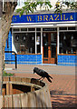
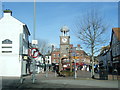
Jackdaw outside Brazil's
Along Chesham High Street which is closed to traffic.
Image: © Des Blenkinsopp
Taken: 6 Aug 2018
0.03 miles
4
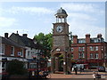
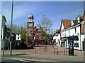
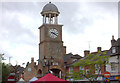
Chesham Clock Tower
The clock tower in Chesham's Market Place is a recent addition, being built in 1992. The clock itself is much older, having originally been part of Chesham Town Hall. The Town Hall had been built in the 18th Century, but was demolished in 1965.
Image: © Malc McDonald
Taken: 4 Jun 2011
0.03 miles

7
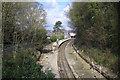
Metropolitan Line railway at Chesham
Chesham is one of the outermost stations on the London Underground system and an hour and a quarter's journey time from Aldgate in the City. The railway line was opened to Chesham in 1889, but a planned extension to Tring was never built. The line was not electrified until 1960, and at one time had a goods yard to the north of the station which is now used as a car park. The service is now limited to a half hourly shuttle train from Chalfont & Latimer station. This view was taken looking northwards from the public footpath overbridge to the south of the station.
Image: © Nigel Cox
Taken: 4 Mar 2006
0.03 miles
9
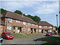
Townfield, Chesham
Housing Association houses in Chesham, Buckinghamshire.
Image: © Malc McDonald
Taken: 4 Jun 2011
0.03 miles
10
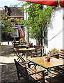
Tables & chairs in the yard
A short alley between High Street and East Street.
Image: © Des Blenkinsopp
Taken: 6 Aug 2018
0.03 miles