IMAGES TAKEN NEAR TO
Rabbits Lane, CHESHAM, HP5 1GB
Introduction
This page details the photographs taken nearby to Rabbits Lane, HP5 1GB by members of the Geograph project.
The Geograph project started in 2005 with the aim of publishing, organising and preserving representative images for every square kilometre of Great Britain, Ireland and the Isle of Man.

There are currently over 7.5m images from over14,400 individuals and you can help contribute to the project by visiting https://www.geograph.org.uk
Image Map
Images are licensed for reuse under creativecommons.org/licenses/by-sa/2.0
Notes
- Clicking on the map will re-center to the selected point.
- The higher the marker number, the further away the image location is from the centre of the postcode.
Image Listing (12 Images Found)
Images are licensed for reuse under creativecommons.org/licenses/by-sa/2.0
Image
Details
Distance
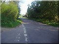
1
Ley Hill Road at junction with Ashridge Lane
Image: © David Howard
Taken: 22 Apr 2011
0.06 miles
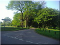
2
Entrance to Chesham & Ley Hill Golf Club
Image: © David Howard
Taken: 22 Apr 2011
0.06 miles
3
Ashridge Lane from junction with Ley Hill Road
Image: © David Howard
Taken: 22 Apr 2011
0.07 miles
4
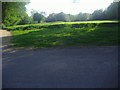
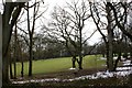
Golf green by Ashridge Lane
Chesham and Ley Hill Golf Club
Image: © David Howard
Taken: 22 Apr 2011
0.08 miles
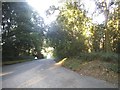
5
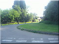
Junction of Ashridge Lane and unnamed road
Image: © David Howard
Taken: 22 Apr 2011
0.08 miles
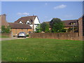

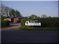
8
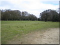
Leyhill Common
Viewed looking northwards from outside Ashridge Farm, the Common is the home of the Chesham & Ley Hill Golf Club whose website is here http://www.cheshamgolf.co.uk/
Image: © Nigel Cox
Taken: 19 Mar 2006
0.15 miles