IMAGES TAKEN NEAR TO
High Street, CHESHAM, HP5 1EB
Introduction
This page details the photographs taken nearby to High Street, HP5 1EB by members of the Geograph project.
The Geograph project started in 2005 with the aim of publishing, organising and preserving representative images for every square kilometre of Great Britain, Ireland and the Isle of Man.

There are currently over 7.5m images from over14,400 individuals and you can help contribute to the project by visiting https://www.geograph.org.uk
Image Map
Images are licensed for reuse under creativecommons.org/licenses/by-sa/2.0
Notes
- Clicking on the map will re-center to the selected point.
- The higher the marker number, the further away the image location is from the centre of the postcode.
Image Listing (196 Images Found)
Images are licensed for reuse under creativecommons.org/licenses/by-sa/2.0
Image
Details
Distance
1
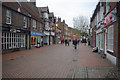
High Street, Chesham
A pedestrianised shopping street serving this Home Counties town with a population of about 20,000.
Image: © Stephen McKay
Taken: 2 Dec 2013
0.02 miles
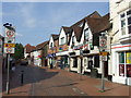
2

130-32 High Street, Chesham
The building on the left and the one next door are both Listed and date from the C18. The High Street is now pedestrianised.
Image: © David Kemp
Taken: 28 Oct 2022
0.02 miles
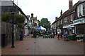
3
Chesham High Street
The High Street would once have been the main route through the centre of Chesham. Through traffic has now been diverted to avoid the high street, which has been pedestrianised.
Image: © Malc McDonald
Taken: 4 Jun 2011
0.02 miles
4
High Street, Chesham
For a Saturday afternoon, this High Street is very empty
Image: © Phillip Perry
Taken: 9 Oct 2010
0.02 miles


7
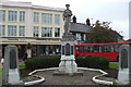
War memorial, Chesham
The locals who died in WWI are on the main memorial,
the two small pillars on either side are for those who died in WWII.
Image: © Phillip Perry
Taken: 9 Oct 2010
0.03 miles

9
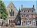
Church and Building Society
United Reformed church and Nationwide Building Society at the top end of Chesham High Street.
Image: © Des Blenkinsopp
Taken: 6 Aug 2018
0.04 miles
10
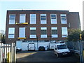
Chesham Telephone Exchange, Bucks (1)
Situated off The Broadway near High Street, this TE, which has the code SMCSH, replaced the former Manual TE in the mid-1960s. It serves 10,080 residential and 563 non-residential premises in Chesham, plus Botley, Chartridge, Hyde Heath and Ley Hill nearby. It has (01494) 77xxxx, 78xxxx, 79xxxx numbers, and its postcode is HP5 1BX.
Image: © David Hillas
Taken: 12 Nov 2008
0.04 miles