IMAGES TAKEN NEAR TO
White Hill, CHESHAM, HP5 1AX
Introduction
This page details the photographs taken nearby to White Hill, HP5 1AX by members of the Geograph project.
The Geograph project started in 2005 with the aim of publishing, organising and preserving representative images for every square kilometre of Great Britain, Ireland and the Isle of Man.

There are currently over 7.5m images from over14,400 individuals and you can help contribute to the project by visiting https://www.geograph.org.uk
Image Map
Images are licensed for reuse under creativecommons.org/licenses/by-sa/2.0
Notes
- Clicking on the map will re-center to the selected point.
- The higher the marker number, the further away the image location is from the centre of the postcode.
Image Listing (5 Images Found)
Images are licensed for reuse under creativecommons.org/licenses/by-sa/2.0
Image
Details
Distance
1
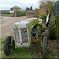
Entrance to Dungrove Farm
One of those tractors that will not be going anywhere, or doing an more useful work, is parked at the farm entrance.
Image: © Graham Horn
Taken: 5 Feb 2011
0.05 miles
2
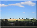
White cloud above Chesham
As seen from Lowndes Park.
Image: © Peter S
Taken: 16 Sep 2018
0.06 miles
3
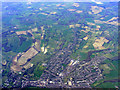
Chesham from the air
Viewed from a Heathrow bound flight from Glasgow.
Image: © Thomas Nugent
Taken: 10 Apr 2011
0.09 miles
4
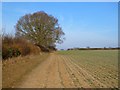
Farmland, Chesham
With a footpath approaching Dungrove Farm alongside a crop of beans.
Image: © Andrew Smith
Taken: 4 Feb 2012
0.13 miles
5
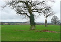
Footpath to Chesham
The path, across the field to the left, goes to Chesham town centre. You are quickly in countryside though, here on the western side of the Tyler's Hill plateau near Dungrove Farm.
Image: © Graham Horn
Taken: 5 Feb 2011
0.21 miles