IMAGES TAKEN NEAR TO
Rossway, BERKHAMSTED, HP4 3UA
Introduction
This page details the photographs taken nearby to Rossway, HP4 3UA by members of the Geograph project.
The Geograph project started in 2005 with the aim of publishing, organising and preserving representative images for every square kilometre of Great Britain, Ireland and the Isle of Man.

There are currently over 7.5m images from over14,400 individuals and you can help contribute to the project by visiting https://www.geograph.org.uk
Image Map
Images are licensed for reuse under creativecommons.org/licenses/by-sa/2.0
Notes
- Clicking on the map will re-center to the selected point.
- The higher the marker number, the further away the image location is from the centre of the postcode.
Image Listing (11 Images Found)
Images are licensed for reuse under creativecommons.org/licenses/by-sa/2.0
Image
Details
Distance
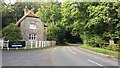
2
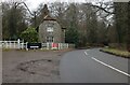
Lodge house across fields
The building is one of the lodge houses to the extensive Rossway estate.
Image: © Rob Farrow
Taken: 2 Mar 2006
0.05 miles
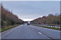
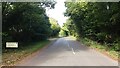
3
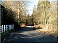
Country Lane through Oak Corner
Taken next to one of the Rossway lodges. The wood to the right is called Oak Corner.
Image: © Rob Farrow
Taken: 2 Mar 2006
0.05 miles
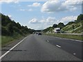
4
Cock Grove
Cock Grove passing Berkhamsted Lodge
Image: © Shaun Ferguson
Taken: 28 Sep 2020
0.05 miles
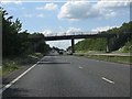

9
Shootersway No Through Road
Shootersway now a no through road from the introduction of the A41 dual carriageway
Image: © Shaun Ferguson
Taken: 28 Sep 2020
0.21 miles