IMAGES TAKEN NEAR TO
Shrublands Avenue, BERKHAMSTED, HP4 3JQ
Introduction
This page details the photographs taken nearby to Shrublands Avenue, HP4 3JQ by members of the Geograph project.
The Geograph project started in 2005 with the aim of publishing, organising and preserving representative images for every square kilometre of Great Britain, Ireland and the Isle of Man.

There are currently over 7.5m images from over14,400 individuals and you can help contribute to the project by visiting https://www.geograph.org.uk
Image Map
Images are licensed for reuse under creativecommons.org/licenses/by-sa/2.0
Notes
- Clicking on the map will re-center to the selected point.
- The higher the marker number, the further away the image location is from the centre of the postcode.
Image Listing (31 Images Found)
Images are licensed for reuse under creativecommons.org/licenses/by-sa/2.0
Image
Details
Distance
1

Cross Oak Road, Berkhamsted
View taken near to its junction with Anglefield Road. Cross Oak Road was formerly called Gillams Lane.
Image: © John Baker
Taken: 10 Oct 2010
0.08 miles
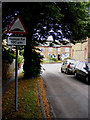
2
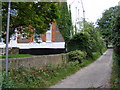
Shrublands Road, Berkhamsted
Escape route to the countryside: the footpath from Shrublands Road to Shootersway.
Image: © David Sands
Taken: 14 Aug 2009
0.10 miles
3
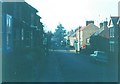
Shrublands Avenue, Berkhamsted
The building with the turret is Rothesay Court and stands on the site of Rothesay School, which I attended from 1951-1954. The building was sold for development in 1988 as the school had been amalgamated with Egerton School in Charles Street several years before. Just beyond the third car on the right, the strip of brightness marks where Cross Oak Road divides Shrublands Avenue from Charles Street, which can be seen disappearing into the distance.
Image: © John Baker
Taken: 10 Oct 2010
0.11 miles
4
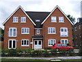
Shrublands Road, Berkhamsted
Brand new apartments in Shrublands Road, some sold and one or two occupied by July 2009.
Image: © David Sands
Taken: 9 Jul 2009
0.11 miles
5
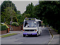
Shrublands Road, Berkhamsted
Bus no 502, known locally as Little Jim's, makes rapid progress along Shrublands Road on a Northchurch to Hemel Hempstead service.
Image: © David Sands
Taken: 9 Jul 2009
0.14 miles
6
Charles Street, Berkhamsted in 1966
The pillar box stood outside Kitsbury Post Office, which stood on the corner of Kitsbury Road.
Image: © John Baker
Taken: Unknown
0.17 miles
7

Charles Street, Berkhamsted
Taken from its junction with North Road
Image: © John Baker
Taken: 10 Oct 2010
0.17 miles
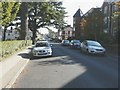
8
Anglefield Road, Berkhamsted
Taken from its junction with Cross Oak Road
Image: © John Baker
Taken: 10 Oct 2010
0.17 miles
9

Charles Street, Berkhamsted
There were a greater number of parked cars than there were in 1966 see http://www.geograph.org.uk/photo/1751372
Image: © John Baker
Taken: 10 Oct 2010
0.17 miles
10
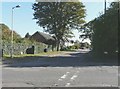
West Road, Berkhamsted
A shady spot in West Road. The road humps are rather inconspicuous.
Image: © David Sands
Taken: 14 Aug 2009
0.17 miles