IMAGES TAKEN NEAR TO
Chandler Mews, BERKHAMSTED, HP4 3HN
Introduction
This page details the photographs taken nearby to Chandler Mews, HP4 3HN by members of the Geograph project.
The Geograph project started in 2005 with the aim of publishing, organising and preserving representative images for every square kilometre of Great Britain, Ireland and the Isle of Man.

There are currently over 7.5m images from over14,400 individuals and you can help contribute to the project by visiting https://www.geograph.org.uk
Image Map
Images are licensed for reuse under creativecommons.org/licenses/by-sa/2.0
Notes
- Clicking on the map will re-center to the selected point.
- The higher the marker number, the further away the image location is from the centre of the postcode.
Image Listing (57 Images Found)
Images are licensed for reuse under creativecommons.org/licenses/by-sa/2.0
Image
Details
Distance
1
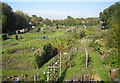
Northchurch: Allotments off New Road
These are the allotments between the River Bulbourne to the left and the Grand Union Canal to the right.
Image: © Nigel Cox
Taken: 21 Oct 2007
0.03 miles
2
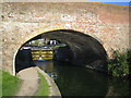
Grand Union Canal in Northchurch
This is Grand Union Canal Bridge No. 139 carrying New Road over the canal. Image in the adjacent grid square is visible through the bridge.
Image: © Nigel Cox
Taken: 21 Oct 2007
0.03 miles
3
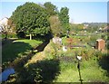
River Bulbourne in Northchurch
Viewed looking upstream from the New Road bridge.
Image: © Nigel Cox
Taken: 21 Oct 2007
0.03 miles
4
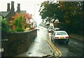
Road Junction
New Road and High Street in Northchurch.
Image: © Wayland Smith
Taken: 18 Apr 2021
0.03 miles
5
High Street, Northchurch in 1987
Seen from its junction with Bell Lane on a very wet October day
Image: © John Baker
Taken: 10 Oct 1987
0.05 miles
6
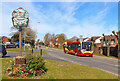
Village Sign
Looking away from Northchurch.
Image: © Wayland Smith
Taken: 18 Apr 2021
0.06 miles
7
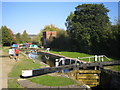
Grand Union Canal: Lock Number 49: Northchurch Top Lock
The brick building beyond the lock has the date 1943, and appears to have some function to do with the canal.
Image: © Nigel Cox
Taken: 21 Oct 2007
0.07 miles
8
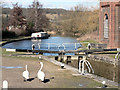
Lock and Canal Basin at Northchurch
Lock and canal basin on the Grand Union Canal at Northchurch. View to the North West, with Norcott Hill in the distance
Image: © Chris Cole
Taken: 25 Feb 2006
0.07 miles
9
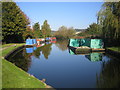
Grand Union Canal in Northchurch
The utilitarian colours of the British Waterways' barges, moored here to the left and right just upstream of Northchurch Lock, compare with the gaily coloured private craft further away. The first narrowboat on the left beyond the blue barge is the Water Spirit of Bradford on Avon.
Image: © Nigel Cox
Taken: 21 Oct 2007
0.07 miles
10
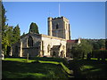
Northchurch: St Mary's Church
There has been a place of Christian worship on this site since before the Norman Conquest in 1066, and some of the foundations are agreed to be Saxon, making the church one of the oldest in Hertfordshire. The bulk of the church dates from the 11th to the 14th centuries with the tower being built in the 15th century.
The churchyard contains the tomb of Peter the Wild Boy, a supposedly feral youth who was discovered in a wood in Hanover in 1725, unable to speak or communicate. How he got to Northchurch can be discovered in the pages of the Church's fine website here http://www.stmarysnorthchurch.com/index.asp
Image: © Nigel Cox
Taken: 21 Oct 2007
0.07 miles