IMAGES TAKEN NEAR TO
Charlotte Close, BERKHAMSTED, HP4 3EB
Introduction
This page details the photographs taken nearby to Charlotte Close, HP4 3EB by members of the Geograph project.
The Geograph project started in 2005 with the aim of publishing, organising and preserving representative images for every square kilometre of Great Britain, Ireland and the Isle of Man.

There are currently over 7.5m images from over14,400 individuals and you can help contribute to the project by visiting https://www.geograph.org.uk
Image Map
Images are licensed for reuse under creativecommons.org/licenses/by-sa/2.0
Notes
- Clicking on the map will re-center to the selected point.
- The higher the marker number, the further away the image location is from the centre of the postcode.
Image Listing (4 Images Found)
Images are licensed for reuse under creativecommons.org/licenses/by-sa/2.0
Image
Details
Distance
1
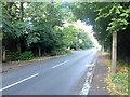
Shootersway, Berkhamsted
Shootersway runs parallel to the A41 on the western edge of the town.
Image: © John Allan
Taken: 12 Oct 2013
0.15 miles
2
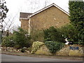
Oakwood, off Shooters Way, Berkhamsted
Image: © Jarvis Docherty
Taken: 21 Feb 2006
0.18 miles
4
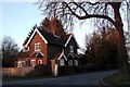
The Lodge, Shootersway
This house known as "The Lodge" sits on the corner where Durrants Lane (seen ahead) leaves Shootersway to descend into the Northchurch end of Berkhamsted. I would guess that it was formerly the lodge to the building that now houses the Egerton-Rothesay School which is 300 yards/metres down Durrants Lane. I will classify it as a lodge, though now I would imagine that it is simply a private house.
Image: © Rob Farrow
Taken: 16 Feb 2008
0.19 miles