IMAGES TAKEN NEAR TO
Chesham Road, BERKHAMSTED, HP4 2SZ
Introduction
This page details the photographs taken nearby to Chesham Road, HP4 2SZ by members of the Geograph project.
The Geograph project started in 2005 with the aim of publishing, organising and preserving representative images for every square kilometre of Great Britain, Ireland and the Isle of Man.

There are currently over 7.5m images from over14,400 individuals and you can help contribute to the project by visiting https://www.geograph.org.uk
Image Map
Images are licensed for reuse under creativecommons.org/licenses/by-sa/2.0
Notes
- Clicking on the map will re-center to the selected point.
- The higher the marker number, the further away the image location is from the centre of the postcode.
Image Listing (6 Images Found)
Images are licensed for reuse under creativecommons.org/licenses/by-sa/2.0
Image
Details
Distance
1
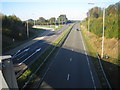
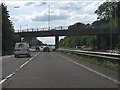
A41 near Berkhamsted
Viewed from the A416 Chesham Road overbridge with the sharp bend of the turn-off from the A41 to the A416 visible to the left.
Image: © Nigel Cox
Taken: 21 Oct 2007
0.16 miles
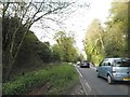
4
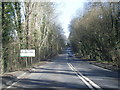
White Hill at the junction of Chesham Road
Image: © David Howard
Taken: 10 Sep 2015
0.19 miles
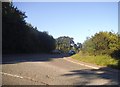
5
A416 Chesham Road at Hertfordshire county boundary
Image: © Colin Pyle
Taken: 29 Feb 2016
0.23 miles
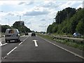
6
A41 - A416 junction bridge, Berkhamsted
Image: © Peter Whatley
Taken: 19 Jun 2012
0.24 miles