IMAGES TAKEN NEAR TO
Frithsden Copse, BERKHAMSTED, HP4 2RQ
Introduction
This page details the photographs taken nearby to Frithsden Copse, HP4 2RQ by members of the Geograph project.
The Geograph project started in 2005 with the aim of publishing, organising and preserving representative images for every square kilometre of Great Britain, Ireland and the Isle of Man.

There are currently over 7.5m images from over14,400 individuals and you can help contribute to the project by visiting https://www.geograph.org.uk
Image Map
Images are licensed for reuse under creativecommons.org/licenses/by-sa/2.0
Notes
- Clicking on the map will re-center to the selected point.
- The higher the marker number, the further away the image location is from the centre of the postcode.
Image Listing (8 Images Found)
Images are licensed for reuse under creativecommons.org/licenses/by-sa/2.0
Image
Details
Distance

4
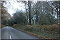
Nettleden Road, Vicarage Road Junction, Potten End
The lane to the right is Vicarage Road which leads to Potten End village.
Image: © Charlotte Farrow
Taken: 11 Mar 2006
0.22 miles
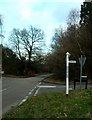
5
Vicarage Road, Potten End
Leading to Potten End village from near Frithsden Copse.
Image: © Charlotte Farrow
Taken: 11 Mar 2006
0.22 miles
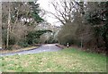
6
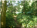
Path leading away from Nettleden Road
Berkhamsted Common.
Image: © Robin Webster
Taken: 19 Sep 2015
0.24 miles
7
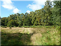
Clearing, Berkhamsted Common
The only clearing not occupied by the golf course on the common.
Image: © Robin Webster
Taken: 19 Sep 2015
0.25 miles
8
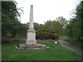
Berkhamsted: The Inns of Court War Memorial
This memorial, on Berkhamsted Common, commemorates the First World War fallen of the Officer Training Corps of the Inns of Court. The Corps used the Common extensively from 1914 to 1919 for training and manoeuvres.
Image: © Nigel Cox
Taken: 7 May 2012
0.25 miles