IMAGES TAKEN NEAR TO
Swing Gate Lane, BERKHAMSTED, HP4 2LJ
Introduction
This page details the photographs taken nearby to Swing Gate Lane, HP4 2LJ by members of the Geograph project.
The Geograph project started in 2005 with the aim of publishing, organising and preserving representative images for every square kilometre of Great Britain, Ireland and the Isle of Man.

There are currently over 7.5m images from over14,400 individuals and you can help contribute to the project by visiting https://www.geograph.org.uk
Image Map
Images are licensed for reuse under creativecommons.org/licenses/by-sa/2.0
Notes
- Clicking on the map will re-center to the selected point.
- The higher the marker number, the further away the image location is from the centre of the postcode.
Image Listing (83 Images Found)
Images are licensed for reuse under creativecommons.org/licenses/by-sa/2.0
Image
Details
Distance
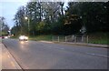
1
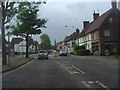
High Street Berkhamsted
At junction of Swing Gate Lane
Image: © David Howard
Taken: 5 May 2011
0.03 miles
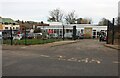
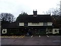
6
Beer garden, The Bull, Berkhamsted
The actual pub is beyond its car park in the High Street.
Image: © Robin Webster
Taken: 28 Jul 2017
0.09 miles
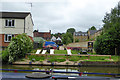
8
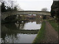
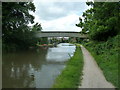
Grand Union Canal Walk
Grand Union Canal Walk at George Street Footbridge
Image: © Shaun Ferguson
Taken: 11 Mar 2017
0.10 miles
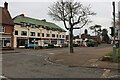
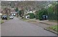
9
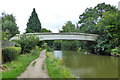
Bridge 142A, Berkhamsted
A footbridge over the Grand Union Canal.
Image: © Robin Webster
Taken: 28 Jul 2017
0.10 miles