IMAGES TAKEN NEAR TO
Cedar Road, BERKHAMSTED, HP4 2LB
Introduction
This page details the photographs taken nearby to Cedar Road, HP4 2LB by members of the Geograph project.
The Geograph project started in 2005 with the aim of publishing, organising and preserving representative images for every square kilometre of Great Britain, Ireland and the Isle of Man.

There are currently over 7.5m images from over14,400 individuals and you can help contribute to the project by visiting https://www.geograph.org.uk
Image Map
Images are licensed for reuse under creativecommons.org/licenses/by-sa/2.0
Notes
- Clicking on the map will re-center to the selected point.
- The higher the marker number, the further away the image location is from the centre of the postcode.
Image Listing (22 Images Found)
Images are licensed for reuse under creativecommons.org/licenses/by-sa/2.0
Image
Details
Distance
1
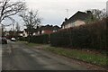
Berkhamsted
Upper Hall Park, with Buncefield still burning several miles to the East
Image: © Ian Rob
Taken: 12 Dec 2005
0.07 miles
5
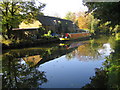
Grand Union Canal in Berkhamsted
The narrowboat is moored at Bank Mill Wharf.
Image: © Nigel Cox
Taken: 21 Oct 2007
0.17 miles
7
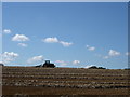
Berkhamsted
Field off Swing Gate Lane looking South
Image: © Ian Rob
Taken: 27 Aug 2005
0.18 miles
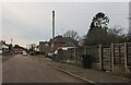
9
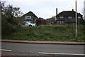
Houses on London Road, Berkhamsted
It shows how much changes in a short period of time. In 2019 the house on the left had chimneys and there was a large fir tree in front of the other one.
Image: © David Howard
Taken: 19 Nov 2022
0.19 miles