IMAGES TAKEN NEAR TO
Greenes Court, Lower Kings Road, BERKHAMSTED, HP4 2JU
Introduction
This page details the photographs taken nearby to Greenes Court, Lower Kings Road, HP4 2JU by members of the Geograph project.
The Geograph project started in 2005 with the aim of publishing, organising and preserving representative images for every square kilometre of Great Britain, Ireland and the Isle of Man.

There are currently over 7.5m images from over14,400 individuals and you can help contribute to the project by visiting https://www.geograph.org.uk
Image Map
Images are licensed for reuse under creativecommons.org/licenses/by-sa/2.0
Notes
- Clicking on the map will re-center to the selected point.
- The higher the marker number, the further away the image location is from the centre of the postcode.
Image Listing (336 Images Found)
Images are licensed for reuse under creativecommons.org/licenses/by-sa/2.0
Image
Details
Distance
6
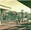
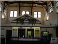
Berkhamsted Railway Station: 1962
In the days before electrification an example of a semaphore signal with the walls of the castle in the background
Image: © John Baker
Taken: Unknown
0.02 miles
7
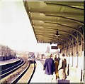
Berkhamsted Railway Station: 1962
In the days before electrification, a train hauled by a diesel locomotive approaches from the direction of Tring
Image: © John Baker
Taken: Unknown
0.02 miles
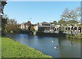
9
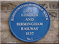
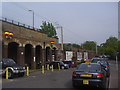
Berkhamsted Railway Station: 1970
This is at the time when the railways were under British Rail. The Grand Union Canal is below the railings.
Image: © John Baker
Taken: Unknown
0.02 miles
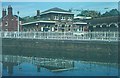
10
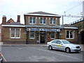
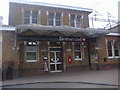
Berkhamsted railway station
From across the Grand Union Canal. A similar view taken in 1970 see http://www.geograph.org.uk/photo/1602160 shows that the house to the left of the station was demolished to make way for new housing.
Image: © John Baker
Taken: 10 Oct 2010
0.02 miles