IMAGES TAKEN NEAR TO
Holly Drive, BERKHAMSTED, HP4 2JR
Introduction
This page details the photographs taken nearby to Holly Drive, HP4 2JR by members of the Geograph project.
The Geograph project started in 2005 with the aim of publishing, organising and preserving representative images for every square kilometre of Great Britain, Ireland and the Isle of Man.

There are currently over 7.5m images from over14,400 individuals and you can help contribute to the project by visiting https://www.geograph.org.uk
Image Map
Images are licensed for reuse under creativecommons.org/licenses/by-sa/2.0
Notes
- Clicking on the map will re-center to the selected point.
- The higher the marker number, the further away the image location is from the centre of the postcode.
Image Listing (75 Images Found)
Images are licensed for reuse under creativecommons.org/licenses/by-sa/2.0
Image
Details
Distance
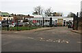
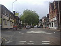
3
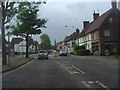
High Street Berkhamsted
At junction of Swing Gate Lane
Image: © David Howard
Taken: 5 May 2011
0.11 miles
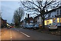
4
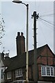
Traditional telegraph pole on High Street, Berkhamsted
I keep finding more of these to the north of London.
Image: © David Howard
Taken: 19 Nov 2022
0.12 miles
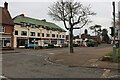
10
High Street Berkhamsted
At junction of Victoria Road
Image: © David Howard
Taken: 5 May 2011
0.14 miles