IMAGES TAKEN NEAR TO
Northchurch, BERKHAMSTED, HP4 1RB
Introduction
This page details the photographs taken nearby to HP4 1RB by members of the Geograph project.
The Geograph project started in 2005 with the aim of publishing, organising and preserving representative images for every square kilometre of Great Britain, Ireland and the Isle of Man.

There are currently over 7.5m images from over14,400 individuals and you can help contribute to the project by visiting https://www.geograph.org.uk
Image Map
Images are licensed for reuse under creativecommons.org/licenses/by-sa/2.0
Notes
- Clicking on the map will re-center to the selected point.
- The higher the marker number, the further away the image location is from the centre of the postcode.
Image Listing (15 Images Found)
Images are licensed for reuse under creativecommons.org/licenses/by-sa/2.0
Image
Details
Distance
1
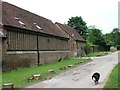
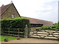
Old Farm Buildings, Norcott Hill Farm, Northchurch
This is a reverse view along the track shown in Image
Image: © Chris Reynolds
Taken: 25 Jun 2009
0.01 miles
2
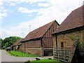
Converted Farm Buildings, Norcott Hill Farm
Note the timber with brick in-fill on the higher part of the walls.
See Image
Image: © Chris Reynolds
Taken: 25 Jun 2009
0.01 miles
3
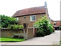
Old Farm House and entrance to farm yard
Image: © Chris Reynolds
Taken: 25 Jun 2009
0.02 miles
4
Norcott Hill Farm, Northchurch
This picture, of the track that runs past Norcott Hill Farm, is taken from a very similar position to an old picture of the farm http://www.judithwhite.myby.co.uk/NORCOTT_FARM.jpg (Original held by Dacorum Heritage Trust www.dacorumheritage.org.uk ).
I simply walked along the track and my analysis of the site is as follows are:
The Gateway to Norcott Hall (Image). Norcott Hall (Image) is a building which, at first sight appears to be an 18th century Georgian Mansion.
A house (Image) which might be the original farmhouse.
Entrance to former farmyard (Image) - all outbuildings appear to be converted to residential.
Two linked farm buildings with backs to the track – one with interesting wood and brickwork (Image) the wood being just visible in the old photograph.
Entrance to farmyard – which forms a rectangle with converted wooden barns.
Another farm barn (converted) with interesting brickwork.
Gateway showing rear of weather-boarded (and converted) farm buildings (Image).
Semi-detached chalet bungalows (Image).
A mid-20th century(?) house and garden.
The track ends about 100 yards further on at a pair of field gates. (Image).
See 'Genealogy in Hertfordshire' website at http://www.hertfordshire-genealogy.co.uk/links/northchurch-norcott-hill.htm for further information, old photograph, and some old maps.
Image: © Chris Reynolds
Taken: 26 Jun 2009
0.03 miles
6
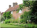
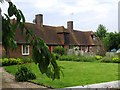
The Farmhouse, Norcott Hill Farm, Northchurch
The 19th century census returns show that there was only one family living at Norcott Hill – that of the farmer. In 1851 the Holinshead family had just taken up residence http://www.judithwhite.myby.co.uk/holinshead.htm while in 1901 the Ashby family were in residence. In my inspection from the public footpath, plus an examination of large scale 1884 Ordnance Survey maps www.old-maps.co.uk , this building is the most obvious candidate for the 19th century farmhouse, with other buildings organised round the farmyard. The 1766 Dury and Andrews map of Hertfordshire www.hertfordshire-genealogy.co.uk/links/map-1766.htm is less clear, but appears to show a different arrangement of buildings – so this farmhouse may be a 19th century rebuild.
See Image
Image: © Chris Reynolds
Taken: 25 Jun 2009
0.03 miles
7
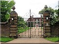
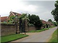
The Gates to Norcott Hall, Northchurch
Image: © Chris Reynolds
Taken: 25 Jun 2009
0.04 miles
8
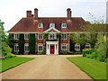
Norcott Hall, Northchurch
I was very surprised to see this 18th century Georgian House as I was not expecting anything so grand at Norcott Hill Farm. It looked too good – and there was no sign of any avenue of 200 year old trees associated with the building. When I got home my doubts were confirmed. There was no mention of it in any of the books in my Hertfordshire history library – and it was definitely not there on large scale maps of 1884 www.old-maps.co.uk . In fact the first reference I found in my own library was that in the mid-1990s the name “Norcott Hall” appears on ordnance survey maps.
It is obviously a 20th century build and a Google search, plus a search of pre-war Kelly's Directories, suggests it was probably built by Thomas Geoffrey Blackwell (1884-1943), who took up residence at Norcott Hill in or shortly before 1937, and died there in 1943. He was deputy chairman of Cross & Blackwell. More recently it was the home of Gordon D Claridge, whose company ran the Port of Lowestoft, and who died in about 1996. He also ran the farm (through a company with his name) and it would appear that the farm buildings were converted to housing shortly after his death.
See also Image
See 'Genealogy in Hertfordshire' web site at http://www.hertfordshire-genealogy.co.uk/links/norcott-hill.htm for further information.
Image: © Chris Reynolds
Taken: 25 Jun 2009
0.04 miles
9
Farmside and Parkfield, Norcott Hill Farm
The position and plot layout of these semi-detached chalet bungalows is similar to many late 19th or early 20th century farm cottages – although such builds were normally houses. They were not there at the time of the 1901 census and I suspect (but may be wrong) that they were built in the early 20th century as part of the Ashridge Estate under Lord Brownlow, of Ashridge House.
See Image
Image: © Chris Reynolds
Taken: 25 Jun 2009
0.06 miles
10
One of the car parks for Northchurch Common
Tracks through the wood lead to a large National Trust area or open grassland, bracken and woods loved by local dog walkers and their mutts.
Image: © Chris Reynolds
Taken: 26 Jun 2009
0.09 miles