IMAGES TAKEN NEAR TO
Castle Hill Avenue, BERKHAMSTED, HP4 1HJ
Introduction
This page details the photographs taken nearby to Castle Hill Avenue, HP4 1HJ by members of the Geograph project.
The Geograph project started in 2005 with the aim of publishing, organising and preserving representative images for every square kilometre of Great Britain, Ireland and the Isle of Man.

There are currently over 7.5m images from over14,400 individuals and you can help contribute to the project by visiting https://www.geograph.org.uk
Image Map
Images are licensed for reuse under creativecommons.org/licenses/by-sa/2.0
Notes
- Clicking on the map will re-center to the selected point.
- The higher the marker number, the further away the image location is from the centre of the postcode.
Image Listing (184 Images Found)
Images are licensed for reuse under creativecommons.org/licenses/by-sa/2.0
Image
Details
Distance
1
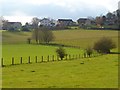
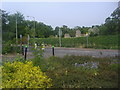
Pasture, Berkhamsted
A view towards some of the large houses on Castle Hill.
Image: © Andrew Smith
Taken: 28 Jan 2012
0.12 miles
3
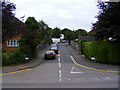
Murray Road, Berkhamsted
Sometimes used for overflow parking (good handbrake essential) for nearby Berkhamsted station, though soon this should cease when parking restrictions take effect.
Image: © David Sands
Taken: 14 Aug 2009
0.15 miles
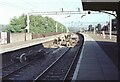
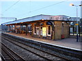
4
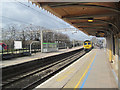
A Freightliner approaches Platform 4, Berkhamsted Station
This picture shows the covered portion of Platform 4 and the uncovered portion of Platform 3.
Freight traffic normally passes through on the slow line/
Image: © Chris Reynolds
Taken: 8 Mar 2012
0.16 miles
5
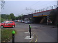
Railway bridge on Brownlow Road, Berkhamsted
Image: © David Howard
Taken: 5 May 2011
0.16 miles
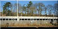
6
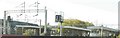
Berkhamsted Railway Station
A close up of http://www.geograph.org.uk/photo/2128013 to show the tatty state of the platform canopies
Image: © John Baker
Taken: 10 Oct 2010
0.16 miles
7
Derailment at Berkhamsted Station (1)
The aftermath of a freight train derailment in the station.
Here we are looking north of west, away from London, at the two Fast lines. On the left is the Down Fast, and closest to the camera is the Up Fast, on which the freight train was travelling. The S-bend mentioned in the Shared Description below can be clearly seen. It looks fairly mild here, but if you are driving a train at 70mph it may seem different!
For further photos of the incident, see Image, Image, Image and Image
The Slow (commuter) lines run between the platforms visible on the far right.
Image: © David Purchase
Taken: 13 Jun 1968
0.16 miles
8
Berkhamsted Station
View ESE towards London; London - Rugby - Crewe etc. West Coast Main Line. This is before Diesels appeared and long before the route was electrified: an Up Local is entering, headed by (push-&-pull-fitted) Ivatt 2MT 2-6-2T No. 41223 (built 11/48, withdrawn 3/66).
Image: © Ben Brooksbank
Taken: 28 Jul 1961
0.16 miles
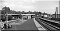
10
Berkhamsted railway station
Berkhamsted railway station, Island platform building on platforms 1 and 2
Image: © Oxyman
Taken: 25 Mar 2007
0.17 miles