IMAGES TAKEN NEAR TO
Deaconsfield Road, HEMEL HEMPSTEAD, HP3 9HZ
Introduction
This page details the photographs taken nearby to Deaconsfield Road, HP3 9HZ by members of the Geograph project.
The Geograph project started in 2005 with the aim of publishing, organising and preserving representative images for every square kilometre of Great Britain, Ireland and the Isle of Man.

There are currently over 7.5m images from over14,400 individuals and you can help contribute to the project by visiting https://www.geograph.org.uk
Image Map
Images are licensed for reuse under creativecommons.org/licenses/by-sa/2.0
Notes
- Clicking on the map will re-center to the selected point.
- The higher the marker number, the further away the image location is from the centre of the postcode.
Image Listing (6 Images Found)
Images are licensed for reuse under creativecommons.org/licenses/by-sa/2.0
Image
Details
Distance
1
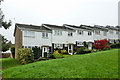
Houses off Sempill Road
One of several similar terraces which are reached on foot, either from a footpath along the foot of the rise or Sempill Road at the top.
Image: © Robin Webster
Taken: 16 Nov 2014
0.05 miles
2
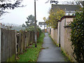
Footpath parallel with Sempill Road
And also parallel with St. Albans Hill, the back gardens of houses on that road are on the left. On the right are newer houses arranged in a series of pedestrian closes running up to Semphill Road.
Image: © Robin Webster
Taken: 16 Nov 2014
0.09 miles
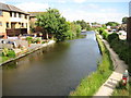
4
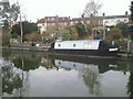
Canalside gardens and mooring at Apsley
Viewed from the Grand Union Canal towpath, these gardens running down to the canal belong to houses in Ebberns Road. At least one owner is making use of the canal to moor a boat.
Image: © Marathon
Taken: 21 Mar 2011
0.24 miles
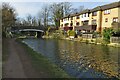
6
Grand Union Canal in Frogmore End
Viewed looking from the Durrants Hill Road bridge.
Image: © Nigel Cox
Taken: 29 Jun 2008
0.25 miles