IMAGES TAKEN NEAR TO
Croxley Road, HEMEL HEMPSTEAD, HP3 9GU
Introduction
This page details the photographs taken nearby to Croxley Road, HP3 9GU by members of the Geograph project.
The Geograph project started in 2005 with the aim of publishing, organising and preserving representative images for every square kilometre of Great Britain, Ireland and the Isle of Man.

There are currently over 7.5m images from over14,400 individuals and you can help contribute to the project by visiting https://www.geograph.org.uk
Image Map
Images are licensed for reuse under creativecommons.org/licenses/by-sa/2.0
Notes
- Clicking on the map will re-center to the selected point.
- The higher the marker number, the further away the image location is from the centre of the postcode.
Image Listing (66 Images Found)
Images are licensed for reuse under creativecommons.org/licenses/by-sa/2.0
Image
Details
Distance
1
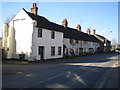
Nash Mills Cottages
These date from the 16th Century and are on the western side of Belswains Lane, Nash Mills.
Image: © Nigel Cox
Taken: 25 Feb 2006
0.05 miles
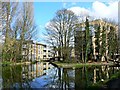
2
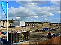
Development site, Nash Mills, Hemel Hempstead
As recently as 2009 this site was covered with industrial buildings and had been for at least 200 years before that. However, the site was sold for residential redevelopment and will, in due course, be used for modern dwellings of the type seen in the background and in this image Image The viewpoint for the photograph seen here was a footbridge so new it isn't yet on the maps.
Image: © Brian Robert Marshall
Taken: 16 Apr 2013
0.05 miles
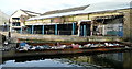
3
Nash Mills paper works
This derelict site was once a hive of activity, served by narrowboats. Taken from Nash Mills top lock.
Image: © Graham Horn
Taken: 10 Apr 2010
0.06 miles
4
Nash Mills paper works
This derelict paper works used to be a hive of activity, served directly from the canal by narrowboats. Now, a barge has been sunk in the entrance to the wharves to prevent access.
Image: © Graham Horn
Taken: 10 Apr 2010
0.06 miles
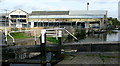
5
Nash Mills Wharf, Hemel Hempstead
Until 2006 this was the location of a paper mill that had been in operation on and off since at least the 18th century. After a period of inactivity the site was cleared in 2010 in preparation for redevelopment as:
..."A collection of stylish 1, 2, 3 & 4 bedroom houses and apartments [that] have been designed to complement the beautiful surroundings and blend sympathetically with the traditional vernacular of the area."
...to quote the developers' publicity material.
The development is proceeding although there is still a lot of construction to be done on other parts of the area covered by the original mill buildings Image
Image: © Brian Robert Marshall
Taken: 16 Apr 2013
0.07 miles
6
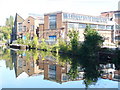
Nash Mills
The old mill buildings on the eastern bank of the Grand Union Canal are now being demolished (2009).
Image: © Colin Smith
Taken: 27 Sep 2009
0.07 miles
7
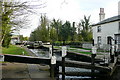
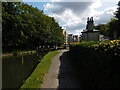
Nash Mills top lock 68
The higher of two locks; the other one can just be seen in the distance. To the left is the former Nash Mills paper works.
Image: © Graham Horn
Taken: 10 Apr 2010
0.07 miles
8
Nash Mills footbridge, Grand Union Canal, Nash Mills
Image: © Bryn Holmes
Taken: 4 Sep 2019
0.07 miles
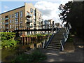
9
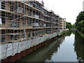
Construction at Nash Mills Wharf
The apartments at Nash Mills Wharf are being built next to the Grand Union Canal in Hemel Hempstead.
Image: © Mat Fascione
Taken: 18 Aug 2015
0.07 miles
10
Nash Mills lock, Grand Union Canal, Nash Mills
Image: © Bryn Holmes
Taken: 4 Sep 2019
0.07 miles