IMAGES TAKEN NEAR TO
Hardings Close, HEMEL HEMPSTEAD, HP3 9AQ
Introduction
This page details the photographs taken nearby to Hardings Close, HP3 9AQ by members of the Geograph project.
The Geograph project started in 2005 with the aim of publishing, organising and preserving representative images for every square kilometre of Great Britain, Ireland and the Isle of Man.

There are currently over 7.5m images from over14,400 individuals and you can help contribute to the project by visiting https://www.geograph.org.uk
Image Map
Images are licensed for reuse under creativecommons.org/licenses/by-sa/2.0
Notes
- Clicking on the map will re-center to the selected point.
- The higher the marker number, the further away the image location is from the centre of the postcode.
Image Listing (43 Images Found)
Images are licensed for reuse under creativecommons.org/licenses/by-sa/2.0
Image
Details
Distance
1
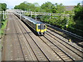
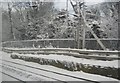
West Coast Main Line in Hemel Hempstead
A down train approaches Hemel Hempstead station in a blur of speed.
Image: © Nigel Cox
Taken: 2 Jun 2010
0.02 miles
2
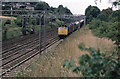
Freight Through Hemel Hempstead
Just south of Hemel Hempstead Station a pair of class 25 locomotives hurry a train of Presflo wagons south along the slow lines. Presflo wagons were designed for the movement of cement in its dry powdered form although by the late 1970's they were being used for other traffic such as pulverised fly-ash from power stations.
On the hillside across the tracks are some of the outbuildings belonging to the Model Farm located beside Roughdown Road.
Image: © Martin Addison
Taken: Unknown
0.03 miles
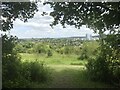
4
Departing Hemel Hempstead
A class 310 electric unit (068) accelerates away from Hemel Hempstead on the slow lines with a service for London Euston. The bridge carrying Roughdown Road over the line is visible on the left.
Image: © Martin Addison
Taken: Unknown
0.07 miles
6
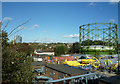
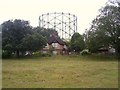
Gasometer beside London Road
The gasometer was repainted in 2007 after complaints that it looked rusty and was an eyesore. The "Kodak Tower", now converted into apartments is in the background.
Image: © Tom Presland
Taken: 18 Oct 2011
0.10 miles
8
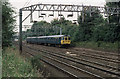
Railway infrastructure by the West Coast Main Line, Hemel Hempstead
Image: © N Chadwick
Taken: 19 Dec 2010
0.11 miles
9
Two Waters Gas works
Gas Holder at Two Waters Gas works, Hemel Hempstead.
Image: © Graham Hale
Taken: 10 Aug 2010
0.11 miles
10
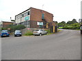
Entrance to Arriva Bus Depot, Hemel Hempstead
Situated in Whiteleaf Road HP3 9PH, this bus depot opened in July 1995 replacing the former bus depot at nearby Two Waters, the latter having since been demolished and replaced by the A414 link road. Approximately fifty vehicles are based here running local town services plus those to Aylesbury, Rickmansworth and Watford. It is also responsible for the Green Line 758 service to Central London. A Green Line coach can just be seen parked in the depot yard.
Image: © David Hillas
Taken: 8 Jul 2016
0.14 miles