IMAGES TAKEN NEAR TO
Lismore, HEMEL HEMPSTEAD, HP3 8TH
Introduction
This page details the photographs taken nearby to Lismore, HP3 8TH by members of the Geograph project.
The Geograph project started in 2005 with the aim of publishing, organising and preserving representative images for every square kilometre of Great Britain, Ireland and the Isle of Man.

There are currently over 7.5m images from over14,400 individuals and you can help contribute to the project by visiting https://www.geograph.org.uk
Image Map
Images are licensed for reuse under creativecommons.org/licenses/by-sa/2.0
Notes
- Clicking on the map will re-center to the selected point.
- The higher the marker number, the further away the image location is from the centre of the postcode.
Image Listing (4 Images Found)
Images are licensed for reuse under creativecommons.org/licenses/by-sa/2.0
Image
Details
Distance
3
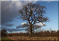
Oak tree, Leverstock Green
An oak tree in an old hedgerow linking two ancient lanes. A map from 1840 shows that this hedge formed the boundary of several fields at that time.
Image: © Allan Rostron
Taken: 6 Feb 2010
0.20 miles