IMAGES TAKEN NEAR TO
Bunkers Lane, HEMEL HEMPSTEAD, HP3 8SW
Introduction
This page details the photographs taken nearby to Bunkers Lane, HP3 8SW by members of the Geograph project.
The Geograph project started in 2005 with the aim of publishing, organising and preserving representative images for every square kilometre of Great Britain, Ireland and the Isle of Man.

There are currently over 7.5m images from over14,400 individuals and you can help contribute to the project by visiting https://www.geograph.org.uk
Image Map
Images are licensed for reuse under creativecommons.org/licenses/by-sa/2.0
Notes
- Clicking on the map will re-center to the selected point.
- The higher the marker number, the further away the image location is from the centre of the postcode.
Image Listing (10 Images Found)
Images are licensed for reuse under creativecommons.org/licenses/by-sa/2.0
Image
Details
Distance
2

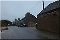
Bunkers Farm
Chiltern Hills farm on the southern edge of Hemel Hempstead.
Image: © Colin Smith
Taken: 28 Sep 2014
0.06 miles
5
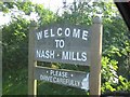
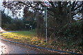
Village welcome sign to Nash Mills
The entrance is into Bunkers Lane but Nash Mills itself is some 4 kilometres away
Image: © Jack Hill
Taken: 11 Jul 2005
0.13 miles
6
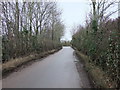
Bunkers Lane at the corner of Bedmond Road
Image: © David Howard
Taken: 25 Nov 2019
0.15 miles
7

Fence and Fields near High Woodhall Lane
Evening with rain approaching from the west. The fence is the boundary of Acorn football club in Bedmond.
Image: © Graham Hale
Taken: 19 May 2009
0.19 miles
8

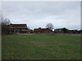
Pimlico - Well Farm
Curious young cattle on farmland in the Chiltern Hills near Hemel Hempstead.
Image: © Colin Smith
Taken: 28 Sep 2014
0.19 miles
9

Oak tree, Leverstock Green
An oak tree in an old hedgerow linking two ancient lanes. A map from 1840 shows that this hedge formed the boundary of several fields at that time.
Image: © Allan Rostron
Taken: 6 Feb 2010
0.24 miles
10

Fields next to Well Farm
Looking towards the sunrise near Pimlico in freezing fog. Taken a few days before Christmas 2007.
Image: © Chrissy Ellis
Taken: 23 Dec 2007
0.25 miles