IMAGES TAKEN NEAR TO
Bunkers Lane, HEMEL HEMPSTEAD, HP3 8RW
Introduction
This page details the photographs taken nearby to Bunkers Lane, HP3 8RW by members of the Geograph project.
The Geograph project started in 2005 with the aim of publishing, organising and preserving representative images for every square kilometre of Great Britain, Ireland and the Isle of Man.

There are currently over 7.5m images from over14,400 individuals and you can help contribute to the project by visiting https://www.geograph.org.uk
Image Map
Images are licensed for reuse under creativecommons.org/licenses/by-sa/2.0
Notes
- Clicking on the map will re-center to the selected point.
- The higher the marker number, the further away the image location is from the centre of the postcode.
Image Listing (15 Images Found)
Images are licensed for reuse under creativecommons.org/licenses/by-sa/2.0
Image
Details
Distance
1
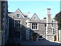
Abbot's Hill
East frontage with flint walling at the independent girls' school. This is an old country house set in extensive grounds.
http://www.abbotshill.herts.sch.uk/
Image: © Colin Smith
Taken: 27 Sep 2009
0.10 miles
2
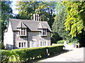
On Abbot's Hill Estate
Delightful flint-walled cottage in the grounds of Abbot's Hill School.
http://www.abbotshill.herts.sch.uk/
Image: © Colin Smith
Taken: 27 Sep 2009
0.11 miles
3
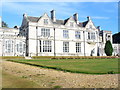
Abbot's Hill School
Former country house on a hillside with sweeping views to west across the Gade Valley. Today it holds an independent girls' school.
http://www.abbotshill.herts.sch.uk/
Image: © Colin Smith
Taken: 27 Sep 2009
0.13 miles
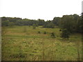
4
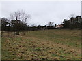
Long Deans Nature Reserve
Long Deans Nature Reserve is semi-improved neutral and calcareous grassland, and noted for its grassland floral communities, butterflies, birds and other invertebrates.
Image: © PAUL FARMER
Taken: 31 Dec 2011
0.16 miles
5
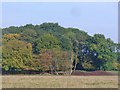
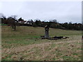
Long Deans
Chiltern landscape of field and woodland beside Highwoodhall Lane near Hemel Hempstead.
Image: © Colin Smith
Taken: 28 Sep 2014
0.18 miles
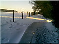
7
Long Deans nature reserve from Bunkers Lane
Image: © David Howard
Taken: 25 Nov 2019
0.22 miles
9
Burnt oak tree on Long Deans Nature Reserve
Image: © PAUL FARMER
Taken: 31 Dec 2011
0.22 miles
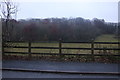
10
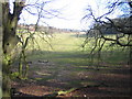
Hemel Hempstead: Long Deans Nature Reserve
Long Deans Nature Reserve comprises this valley and the woodland to the right, and is managed by the Herts & Middlesex Wildlife Trust. Viewed looking north eastwards up the valley with Bunker's Lane to the left.
Image: © Nigel Cox
Taken: 25 Feb 2006
0.24 miles