IMAGES TAKEN NEAR TO
Georgewood Road, HEMEL HEMPSTEAD, HP3 8AN
Introduction
This page details the photographs taken nearby to Georgewood Road, HP3 8AN by members of the Geograph project.
The Geograph project started in 2005 with the aim of publishing, organising and preserving representative images for every square kilometre of Great Britain, Ireland and the Isle of Man.

There are currently over 7.5m images from over14,400 individuals and you can help contribute to the project by visiting https://www.geograph.org.uk
Image Map
Images are licensed for reuse under creativecommons.org/licenses/by-sa/2.0
Notes
- Clicking on the map will re-center to the selected point.
- The higher the marker number, the further away the image location is from the centre of the postcode.
Image Listing (5 Images Found)
Images are licensed for reuse under creativecommons.org/licenses/by-sa/2.0
Image
Details
Distance
1
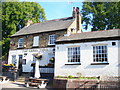
The Three Tuns
Old brick-built pub on Belswains Lane, Apsley. It faces Nash Mills - now under demolition (2009).
Image: © Colin Smith
Taken: 27 Sep 2009
0.17 miles
2
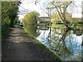
Grand Union Canal, opposite Swan Mead, Hemel Hempstead (1 of 3)
The relatively modern housing development on the opposite side of the canal comprises roads named after a selection of British birds associated with water. These include Kingfisher, Mallard, Heron, Teal and Bittern. Moored alongside the towpath are several narrowboats that might have spent the winter here.
Image: © Brian Robert Marshall
Taken: 16 Apr 2013
0.24 miles
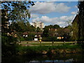
5
Dickinson Quay, Apsley
Looking towards Belswains Lane from Evans Wharf.
Image: © Richard Vince
Taken: 19 Sep 2015
0.25 miles