IMAGES TAKEN NEAR TO
Redling Drive, HEMEL HEMPSTEAD, HP3 0RF
Introduction
This page details the photographs taken nearby to Redling Drive, HP3 0RF by members of the Geograph project.
The Geograph project started in 2005 with the aim of publishing, organising and preserving representative images for every square kilometre of Great Britain, Ireland and the Isle of Man.

There are currently over 7.5m images from over14,400 individuals and you can help contribute to the project by visiting https://www.geograph.org.uk
Image Map
Images are licensed for reuse under creativecommons.org/licenses/by-sa/2.0
Notes
- Clicking on the map will re-center to the selected point.
- The higher the marker number, the further away the image location is from the centre of the postcode.
Image Listing (4 Images Found)
Images are licensed for reuse under creativecommons.org/licenses/by-sa/2.0
Image
Details
Distance
1
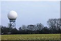
National Air Traffic Service radar dome at Bovingdon
The radar dome on Long Lane replaced the taller mast shown in Image
Image: © Simon Mortimer
Taken: 27 Mar 2013
0.10 miles
2
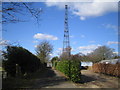
Bovingdon: Long Lane Mast
Viewed looking westwards from Long Lane.
Image: © Nigel Cox
Taken: 5 Mar 2006
0.14 miles
3
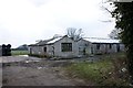
Barns at Chiltern Farm, Shantock Lane
Looking south from the gateway on Shantock Lane.
Image: © Simon Mortimer
Taken: 27 Mar 2013
0.24 miles
4
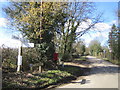
Bovingdon: Shantock Lane
Viewed looking westwards from the junction with Long Lane.
Image: © Nigel Cox
Taken: 5 Mar 2006
0.24 miles