IMAGES TAKEN NEAR TO
Maple Hill, HEMEL HEMPSTEAD, HP3 0NL
Introduction
This page details the photographs taken nearby to Maple Hill, HP3 0NL by members of the Geograph project.
The Geograph project started in 2005 with the aim of publishing, organising and preserving representative images for every square kilometre of Great Britain, Ireland and the Isle of Man.

There are currently over 7.5m images from over14,400 individuals and you can help contribute to the project by visiting https://www.geograph.org.uk
Image Map
Images are licensed for reuse under creativecommons.org/licenses/by-sa/2.0
Notes
- Clicking on the map will re-center to the selected point.
- The higher the marker number, the further away the image location is from the centre of the postcode.
Image Listing (3 Images Found)
Images are licensed for reuse under creativecommons.org/licenses/by-sa/2.0
Image
Details
Distance
1
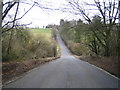
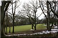
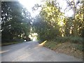
Ley Hill: Buckinghamshire & Hertfordshire
Two counties for the price of one here - a view looking north eastwards along Ley Hill from Buckinghamshire into Hertfordshire (and from Chiltern District Council into Dacorum District Council). The boundary runs across the road at the foot of the hill.
Image: © Nigel Cox
Taken: 19 Mar 2006
0.15 miles