IMAGES TAKEN NEAR TO
Long Lane, HEMEL HEMPSTEAD, HP3 0ND
Introduction
This page details the photographs taken nearby to Long Lane, HP3 0ND by members of the Geograph project.
The Geograph project started in 2005 with the aim of publishing, organising and preserving representative images for every square kilometre of Great Britain, Ireland and the Isle of Man.

There are currently over 7.5m images from over14,400 individuals and you can help contribute to the project by visiting https://www.geograph.org.uk
Image Map
Images are licensed for reuse under creativecommons.org/licenses/by-sa/2.0
Notes
- Clicking on the map will re-center to the selected point.
- The higher the marker number, the further away the image location is from the centre of the postcode.
Image Listing (5 Images Found)
Images are licensed for reuse under creativecommons.org/licenses/by-sa/2.0
Image
Details
Distance
3
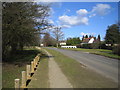
Bovingdon: Bovingdon Green
Viewed looking northwards along The Green towards Bovingdon.
Image: © Nigel Cox
Taken: 5 Mar 2006
0.15 miles
5
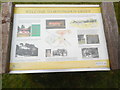
'Welcome to Bovingdon Green' Information Board
This information board is located at the east end of Bovingdon Green HP3 0LF and is maintained by Bovingdon Parish Council. It has the following wording:
WELCOME TO BOVINGDON GREEN
At the same time as Bovingdon began to grow around the Church, half a mile up
Green Lane the area centred around this 8 acre Green was settled. Bovingdon
Green consisted of farms and cottages, one of the earliest of which is Water
Lane Cottage built in the 1400s and once part of a medieval hall house. The
Green has been common land since the 1600s, this would have allowed the
villagers to graze their animals. In the 18th century the Green was on the
route between Berkhamsted and Rickmansworth when the pond would be a useful
watering stop. Nowadays the cricket pitch is a dominant feature of the Green,
the club was started in 1884.
Left column
Green Farm also dates from the 1400s. In the 1930s some of the farmland was
sold to a brickmaker. When the clay was worked out, this land was passed to the
Box Moor Trust who now manages this area for wildlife to the benefit of us all.
Photo-Golden Jubilee 2002
Green rectangle
Golden Jubilee
Picnic on the Green
Monday 3rd June
Bovingdon Green
Bring your own Picnic!
Starts at 1.00pm
1pm - Scottish Piper
Other attractions include:
Short cricket matches
Tug-o-War
Morris Dancing
Egg Throwing Contest
Jazz Band
Hot Dog Stand
Roundabout
So see you there!
The Funfair comes to the Green each September. Bovingdon 'Revels', Jubilee
picnics and Dog Shows have been held on the Green.
Photo-Royal Oak Pub early 1900s
The original Royal Oak stood much nearer the junction of the Green with Water
and Middle Lanes. It was replaced in the 1950s.
Middle Column
Photo-Green Farm
Map of Bovingdon Green
For those unable to work on the land, or earn money straw plaiting, there was
Bovingdon 'Poor House' located by the side of the Green. The house had room
for 30 paupers and even a cage for those who misbehaved. A field nearby was
called Workhouse Meadow.
Right column
Image-Cricket on the Green
When the Green was given to the then Rural District Council, it was with the
proviso that the Cricket Club could continue to use the Green. At one time
the Club's president was Sir Gordon Cunard (Cunard Shipping Line) who lived
in nearby Shantock Hall. The Cunard family grave can be seen in Bovingdon
Churchyard.
Photos: Cunard family grave including gravestone of Gordon Cunard, Baronet,
1857-1933
During WW2 the Americans used the pitch as a baseball square and also tried
their hand at cricket.
Photo: Americans reading the rules of cricket.
Image: © David Hillas
Taken: 14 Mar 2020
0.21 miles