IMAGES TAKEN NEAR TO
Chipperfield Road, HEMEL HEMPSTEAD, HP3 0JW
Introduction
This page details the photographs taken nearby to Chipperfield Road, HP3 0JW by members of the Geograph project.
The Geograph project started in 2005 with the aim of publishing, organising and preserving representative images for every square kilometre of Great Britain, Ireland and the Isle of Man.

There are currently over 7.5m images from over14,400 individuals and you can help contribute to the project by visiting https://www.geograph.org.uk
Image Map
Images are licensed for reuse under creativecommons.org/licenses/by-sa/2.0
Notes
- Clicking on the map will re-center to the selected point.
- The higher the marker number, the further away the image location is from the centre of the postcode.
Image Listing (8 Images Found)
Images are licensed for reuse under creativecommons.org/licenses/by-sa/2.0
Image
Details
Distance
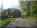
2
Public footpath off Chipperfield Road, Bovingdon
Image: © David Howard
Taken: 8 May 2012
0.08 miles
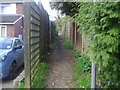
3
Chiltern Way
Chiltern Way crosses Chipperfield Road to head up Austins Mead
Image: © Shaun Ferguson
Taken: 7 May 2010
0.09 miles
4
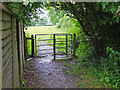
Jammed Kissing gate on Chiltern Way
The catch on this kissing gate was jammed.
Image: © Tom Presland
Taken: 3 Jul 2012
0.14 miles
5
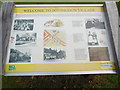
Information Board in Chipperfield Road
This information board is located in Chipperfield Road HP3 0JN opposite Austins Mead and is maintained by Bovingdon Parish Council. It has the following wording:
WELCOME TO BOVINGDON VILLAGE
The settlement of Bovingdon dates from the 1200s when the forest was cleared and arable farming began. The village gradually grew over the centuries eventually appearing in its present form in the 1900s. You are standing on
Chipperfield Road this was formally known as Blacksmiths Hill, the village forge
being located near Farriers Close. The house called 'The Close' was purpose built in the 1840's as our village school; this was outgrown in the 1920's when
it relocated to the High Street. Adjacent to the old school, Austins Mead housing was built for the RAF serving at Bovingdon Airfield post WW2, the RAF
moved out in the 1970's. Prior to this, the field was used by Bovingdon Football
Club.
Left column
Photo: Bovingdon School 1910 - Infants Class
Photo: Bovingdon Forge in the 1900s
Photo: main village blacksmith, by the 1920s repairing cars
Middle column
Image of house
Map of the southern part of Bovingdon village
Photo: Druce butchers circa 1900, original telephone number 5
Right column
Photo: Bull Cottages in Church Street once housed the Post Office. Circa 1912,
it shows Mr & Mrs Burgin and their staff. They also operated the first village
telephone exchange.
Photo: Up to the 1930s roads were made of earth, flints/stones; they were wet
and muddy in winter, dry and dusty in summer. Women, as shown in the photo,
would pick stones from the fields which men would break and place in the
potholes.
Photo: Floods have often occurred at the junction of Chipperfield Road and the
High Street, so much so the area is known as 'The Docks'. This picture is pre-
WW1, the earliest recorded flood was in 1634 and the latest 2016.
Image: © David Hillas
Taken: 4 Sep 2020
0.14 miles
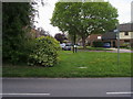
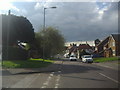
6
Austins Mead from Chipperfield Road, Bovingdon
Image: © David Howard
Taken: 8 May 2012
0.15 miles
8
Chiltern Way
Chiltern Way where the path from Church Street to Longcroft Lane cuts across by the hedge line.
Image: © Shaun Ferguson
Taken: 7 May 2010
0.22 miles