IMAGES TAKEN NEAR TO
Chipperfield Road, HEMEL HEMPSTEAD, HP3 0JR
Introduction
This page details the photographs taken nearby to Chipperfield Road, HP3 0JR by members of the Geograph project.
The Geograph project started in 2005 with the aim of publishing, organising and preserving representative images for every square kilometre of Great Britain, Ireland and the Isle of Man.

There are currently over 7.5m images from over14,400 individuals and you can help contribute to the project by visiting https://www.geograph.org.uk
Image Map
Images are licensed for reuse under creativecommons.org/licenses/by-sa/2.0
Notes
- Clicking on the map will re-center to the selected point.
- The higher the marker number, the further away the image location is from the centre of the postcode.
Image Listing (4 Images Found)
Images are licensed for reuse under creativecommons.org/licenses/by-sa/2.0
Image
Details
Distance
1
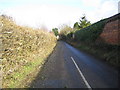
Bovingdon: Longcroft Lane
Hedge flailing was in progress just down the lane in this view taken looking northwards from the junction with Chipperfield Road.
Image: © Nigel Cox
Taken: 21 Jan 2006
0.14 miles
2
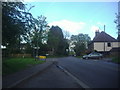
Chipperfield Road at the junction of Flaunden Lane
Image: © David Howard
Taken: 8 May 2012
0.14 miles
4
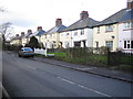
Bovingdon: Boundary Cottages
A neat row of semi-detached houses on Chipperfield Road.
Image: © Nigel Cox
Taken: 21 Jan 2006
0.21 miles