IMAGES TAKEN NEAR TO
Church Lane, HEMEL HEMPSTEAD, HP3 0HS
Introduction
This page details the photographs taken nearby to Church Lane, HP3 0HS by members of the Geograph project.
The Geograph project started in 2005 with the aim of publishing, organising and preserving representative images for every square kilometre of Great Britain, Ireland and the Isle of Man.

There are currently over 7.5m images from over14,400 individuals and you can help contribute to the project by visiting https://www.geograph.org.uk
Image Map
Images are licensed for reuse under creativecommons.org/licenses/by-sa/2.0
Notes
- Clicking on the map will re-center to the selected point.
- The higher the marker number, the further away the image location is from the centre of the postcode.
Image Listing (32 Images Found)
Images are licensed for reuse under creativecommons.org/licenses/by-sa/2.0
Image
Details
Distance
1

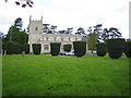
Approach to St Lawrence, Bovingdon
The church is slightly off the axis of this impressive yew avenue.
Image: © Chris Brown
Taken: 20 Aug 2017
0.04 miles
2
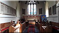
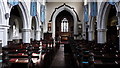
St Lawrence, Bovingdon
View west to the tower screen. The well-preserved church was built in 1845 to a serious and straightforward Gothic design by T Talbot Bury.
Image: © Chris Brown
Taken: 20 Aug 2017
0.04 miles
3
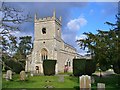
Bovingdon Church
St Lawrence Church was built in 1845 by Talbot Bury.
Image: © Colin Smith
Taken: 20 Mar 2016
0.04 miles
4
Bovingdon: The Church of St Lawrence
The Church was originally built in the 14th century but was rebuilt in 1846 and only the original tower now remains. The Church has one of the largest graveyards in Hertfordshire, which is characterized by the numerous cup-shaped yew trees.
Image: © Nigel Cox
Taken: 28 May 2006
0.04 miles
5

St Lawrence, Bovingdon
With a backdrop of pines and a foreground of yews and freshly-mown grass.
Image: © Chris Brown
Taken: 20 Aug 2017
0.05 miles
6
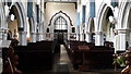
St Lawrence, Bovingdon
Looking east along the nave in this early Gothic revival church, by T Talbot Bury and dating from 1845. Furnishings have survived largely unaltered.
Image: © Chris Brown
Taken: 20 Aug 2017
0.06 miles
7
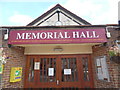
Entrance to Bovingdon Memorial Hall
This photo shows the entrance to the Memorial Hall with a clock above it. The sign says the following:
MEMORIAL HALL
To the glory of God in thankfulness for service sacrifice and victory 1914-1918
Village Hall erected 1921
A defibrillator can be seen to the left of the entrance doors whilst there is a
noticeboard to the right.
Image: © David Hillas
Taken: 4 Sep 2020
0.06 miles
8
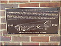
Plaque outside Bovingdon Memorial Hall
This photo shows the plaque outside the memorial hall in High Street. It has the following wording:
IN COMMEMORATION
Of members of the 3rd Air Division, 7531st Air Base Squadron and Support Units,
3rd U.S. Air Force who served from Bovingdon Airfield. The Units provided
proficiency flying, operational flights and communications in support of the
North Atlantic Treaty Organisation. The dedication to service and devotion to
duty of the U.S. Air Force members contributed to the deterrence of tyranny and
the preservation of peace and freedom.
1949 Image of U.S. Air Force plane 43-49774 1962
Dedicated September 20, 1998
Image: © David Hillas
Taken: 4 Sep 2020
0.06 miles
9

Bovingdon Memorial Hall
Situated in High Street HP3 0HJ, this war memorial hall was built by significant donations from local people and public subscription to commemorate the fallen of the Great War. It was opened in 1921, having cost £3,000 to build, and immediately became the centre of village life. Today, it is used for various village activities and houses the office of Bovingdon Parish Council.
Image: © David Hillas
Taken: 4 Sep 2020
0.06 miles