IMAGES TAKEN NEAR TO
Swallow Walk, HEMEL HEMPSTEAD, HP3 0FY
Introduction
This page details the photographs taken nearby to Swallow Walk, HP3 0FY by members of the Geograph project.
The Geograph project started in 2005 with the aim of publishing, organising and preserving representative images for every square kilometre of Great Britain, Ireland and the Isle of Man.

There are currently over 7.5m images from over14,400 individuals and you can help contribute to the project by visiting https://www.geograph.org.uk
Image Map
Images are licensed for reuse under creativecommons.org/licenses/by-sa/2.0
Notes
- Clicking on the map will re-center to the selected point.
- The higher the marker number, the further away the image location is from the centre of the postcode.
Image Listing (22 Images Found)
Images are licensed for reuse under creativecommons.org/licenses/by-sa/2.0
Image
Details
Distance
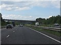
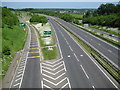
4
A41 Langley Bypass
This is a view from the other end of the Featherbed Lane bridge, taken over three years after the first. The northbound slip road to the A414 Hemel Hempstead junction has just started to peel off from the main carriageway.
Image: © Nigel Cox
Taken: 31 May 2009
0.11 miles
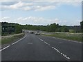
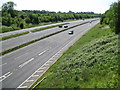
7
A41 Langley Bypass
Viewed from the Featherbed Lane overbridge in Apsley, the bypass was built in 1993.
Image: © Nigel Cox
Taken: 22 Apr 2006
0.12 miles
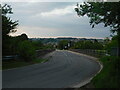
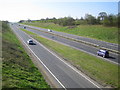
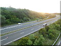
8
A41 at the A414 Hemel Hempstead junction
The slip road off the northbound carriageway peels off on the left here to Image Since this is an A road and not a motorway there is a crossing facility complete with a couple of Give Way signs to enable cyclists to cross over the slip road and carry on along the main carriageway. The two white squares in the main carriageway are markers for use by the Police using VASCAR (Visual Average Speed Computer And Recorder) methods. There will be another set of marks either prior to these, or ahead of them, at a known distance, such that, if a vehicle can be timed between the two marks, usually by helicopter, its average speed can be simply computed.
On a more engaging note what a wonderful display of daisies 2009 has brought to roadside verges!
Image: © Nigel Cox
Taken: 31 May 2009
0.13 miles
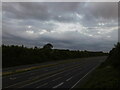
9
A41 road, at the Hemel Hempstead junction
Image: © Bryn Holmes
Taken: 13 Jun 2017
0.15 miles