IMAGES TAKEN NEAR TO
Deanfield, HEMEL HEMPSTEAD, HP3 0EW
Introduction
This page details the photographs taken nearby to Deanfield, HP3 0EW by members of the Geograph project.
The Geograph project started in 2005 with the aim of publishing, organising and preserving representative images for every square kilometre of Great Britain, Ireland and the Isle of Man.

There are currently over 7.5m images from over14,400 individuals and you can help contribute to the project by visiting https://www.geograph.org.uk
Image Map
Images are licensed for reuse under creativecommons.org/licenses/by-sa/2.0
Notes
- Clicking on the map will re-center to the selected point.
- The higher the marker number, the further away the image location is from the centre of the postcode.
Image Listing (13 Images Found)
Images are licensed for reuse under creativecommons.org/licenses/by-sa/2.0
Image
Details
Distance
1
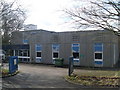
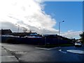
Telephone Exchange, Bovingdon, Herts
Situated in Hyde Lane near Chesham Road, this TE, which has the code SMBD, replaced the now demolished former TE in High Street in the early 1970s. It provides telephone and broadband services to 2,325 residential and 134 non-residential premises in Bovingdon plus Flaunden and Whelpley Hill nearby. The blue areas round the windows could do with a lick of paint. The numbering range of this TE is (01442) 83xxxx, the (01442) referring to the Hemel Hempstead group of six TEs, and its postcode is HP3 0EF.
Image: © David Hillas
Taken: 4 Mar 2009
0.12 miles
2
Bovingdon: Millennium Village Sign
Bovingdon's Millennium Village Sign in the High Street features images of the Church of St Lawrence Image and the Old Well Image .
Image: © Nigel Cox
Taken: 28 May 2006
0.18 miles
3
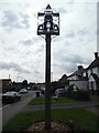
Millennium Village Sign, Bovingdon
This village sign is in the High Street HP3 0HJ, and was erected to commemorate the Millennium. It comprises of St Lawrence Parish Church, while above it is the Ryder Memorial of a well cover for a hand pump.
Image: © David Hillas
Taken: 27 Aug 2020
0.21 miles
4
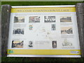
'Welcome to Bovingdon Village' Information Board (2)
This information board in located in High Street HP3 0HJ. It has the same wording and illustrations as the information board in Chipperfield Road, https://www.geograph.org.uk/photo/6587859 refers.
Image: © David Hillas
Taken: 27 Aug 2020
0.22 miles
5
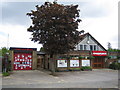
Former car sales lot
Seems to be undergoing demolition.
Image: © Bikeboy
Taken: 1 Nov 2014
0.22 miles
6
Bovingdon: Fire Station and Parish Council Offices
In April 2006 Hertfordshire County Council voted to close down the local fire station in Bovingdon, and there is a heated campaign to save it. The campaign's website is here http://www.save-bovingdon-firestation.co.uk/
Image: © Nigel Cox
Taken: 28 May 2006
0.23 miles
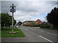
7
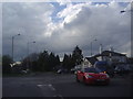
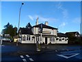
Roundabout on Chesham Road, Bovingdon
At the end of the High Street
Image: © David Howard
Taken: 8 May 2012
0.24 miles
8
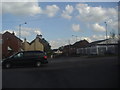
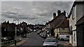
Chesham Road, Bovingdon
Chesham Road runs between Chesham on the right side and Hemel Hempstead about the same distance on the left. The High Street can be seen opposite.
Image: © David Howard
Taken: 8 May 2012
0.24 miles
10
High Street, Bovingdon
The old part of a much-expanded village focuses on this staggered crossroads with a pond (in the greenery at the bottom left corner), well shelter and the hanging frame for a pub sign, sadly empty.
Image: © Chris Brown
Taken: 20 Aug 2017
0.25 miles