IMAGES TAKEN NEAR TO
Hempstead Road, HEMEL HEMPSTEAD, HP3 0DT
Introduction
This page details the photographs taken nearby to Hempstead Road, HP3 0DT by members of the Geograph project.
The Geograph project started in 2005 with the aim of publishing, organising and preserving representative images for every square kilometre of Great Britain, Ireland and the Isle of Man.

There are currently over 7.5m images from over14,400 individuals and you can help contribute to the project by visiting https://www.geograph.org.uk
Image Map
Images are licensed for reuse under creativecommons.org/licenses/by-sa/2.0
Notes
- Clicking on the map will re-center to the selected point.
- The higher the marker number, the further away the image location is from the centre of the postcode.
Image Listing (4 Images Found)
Images are licensed for reuse under creativecommons.org/licenses/by-sa/2.0
Image
Details
Distance
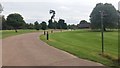
1
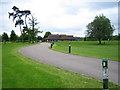
Bovingdon: Little Hay Golf Club
This municipal golf course is owned by Dacorum Borough Council, and was opened on the farmland of the former Little Hay Farm in 1977. The Club's website is here http://www.littlehaygolfclub.co.uk/
Image: © Nigel Cox
Taken: 28 May 2006
0.02 miles
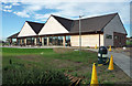
3
Path heading to the B4505
Path heading up past the Little Hay Golf Club House towards the B4505
Image: © Shaun Ferguson
Taken: 4 Sep 2020
0.02 miles
4
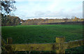
View from Private Road
View from private road towards B4505
Image: © Tom Presland
Taken: 24 Nov 2010
0.25 miles