IMAGES TAKEN NEAR TO
Felden Drive, HEMEL HEMPSTEAD, HP3 0BD
Introduction
This page details the photographs taken nearby to Felden Drive, HP3 0BD by members of the Geograph project.
The Geograph project started in 2005 with the aim of publishing, organising and preserving representative images for every square kilometre of Great Britain, Ireland and the Isle of Man.

There are currently over 7.5m images from over14,400 individuals and you can help contribute to the project by visiting https://www.geograph.org.uk
Image Map
Images are licensed for reuse under creativecommons.org/licenses/by-sa/2.0
Notes
- Clicking on the map will re-center to the selected point.
- The higher the marker number, the further away the image location is from the centre of the postcode.
Image Listing (13 Images Found)
Images are licensed for reuse under creativecommons.org/licenses/by-sa/2.0
Image
Details
Distance
1
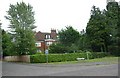
House overlooking common
This house faces directly on to the Sheethanger Common.
Image: © Jack Hill
Taken: 3 Jul 2005
0.09 miles
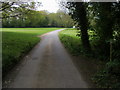
3
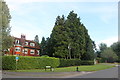
Felden Lane at the corner of Felden Drive
Image: © David Howard
Taken: 17 Aug 2019
0.10 miles
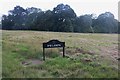
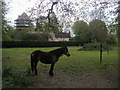
5
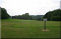
Boxmoor golf course
Viewpoint from the highest part of the golf course.
Image: © Jack Hill
Taken: 3 Jul 2005
0.15 miles
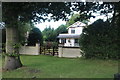
7
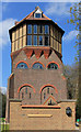
Water Tower house
Still being converted when this shot was taken.
Image: © Tom Presland
Taken: 2 Apr 2012
0.19 miles
9
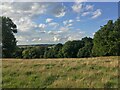
Chiltern Way
Chiltern Way crossing Boxmoor Golf Club on Sheethanger Common
Image: © Shaun Ferguson
Taken: 7 May 2010
0.21 miles
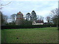
10
Water Tower
Water Tower under redevelopment on Featherbed Lane Felden
Image: © Shaun Ferguson
Taken: 7 May 2010
0.21 miles