IMAGES TAKEN NEAR TO
The Courtyard, HEMEL HEMPSTEAD, HP3 0AS
Introduction
This page details the photographs taken nearby to The Courtyard, HP3 0AS by members of the Geograph project.
The Geograph project started in 2005 with the aim of publishing, organising and preserving representative images for every square kilometre of Great Britain, Ireland and the Isle of Man.

There are currently over 7.5m images from over14,400 individuals and you can help contribute to the project by visiting https://www.geograph.org.uk
Image Map
Images are licensed for reuse under creativecommons.org/licenses/by-sa/2.0
Notes
- Clicking on the map will re-center to the selected point.
- The higher the marker number, the further away the image location is from the centre of the postcode.
Image Listing (7 Images Found)
Images are licensed for reuse under creativecommons.org/licenses/by-sa/2.0
Image
Details
Distance
1
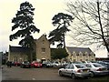
Shendish Manor Golf Clubhouse
Shendish Manor Golf Course is a par 70, 18 hole course.
Image: © Graham Hale
Taken: 15 Feb 2011
0.05 miles
2
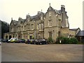
Shendish Manor Hotel
This Victorian house was built around 1853 for Charles Longman of Longman's publishers. It remained in the Longman family until 1936 when the house and 90 acres of park were sold to the John Dickinson Company who used it as the company sports club. In 1994, it was turned into a hotel and golf course.
Image: © Graham Hale
Taken: 15 Feb 2011
0.07 miles
3
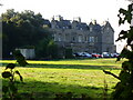
Shendish Manor
Old country house set in extensive grounds south-west of Apsley. It is now a conference & leisure centre and has an adjacent golf course.
http://www.shendish-manor.com/
Image: © Colin Smith
Taken: 27 Sep 2009
0.07 miles
4
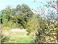
Footpath by Rucklers Lane
Grassy path through scrubland on the hillside north of Rucklers Lane.
Image: © Colin Smith
Taken: 27 Sep 2009
0.16 miles
5
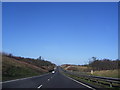
A41 near Hemel Hempstead
A photo of the A41 approaching Hemel Hempstead.
Image: © Daniel
Taken: 3 Jan 2007
0.19 miles
6

Shendish Manor golf course (in the snow), Apsley
Image: © Bryn Holmes
Taken: 16 Dec 2022
0.19 miles
7
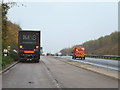
Lay-by on A41
Rather oddly, the Ordnance Survey mapping shows this lay-by in the wrong place, somewhat further along the road. There is no sign it ever was there.
Image: © Robin Webster
Taken: 16 Nov 2014
0.21 miles