IMAGES TAKEN NEAR TO
Manorville Road, HEMEL HEMPSTEAD, HP3 0AP
Introduction
This page details the photographs taken nearby to Manorville Road, HP3 0AP by members of the Geograph project.
The Geograph project started in 2005 with the aim of publishing, organising and preserving representative images for every square kilometre of Great Britain, Ireland and the Isle of Man.

There are currently over 7.5m images from over14,400 individuals and you can help contribute to the project by visiting https://www.geograph.org.uk
Image Map
Images are licensed for reuse under creativecommons.org/licenses/by-sa/2.0
Notes
- Clicking on the map will re-center to the selected point.
- The higher the marker number, the further away the image location is from the centre of the postcode.
Image Listing (34 Images Found)
Images are licensed for reuse under creativecommons.org/licenses/by-sa/2.0
Image
Details
Distance
6
King Edward Street, Manor Estate, Apsley
Image: © Bryn Holmes
Taken: 4 Sep 2019
0.12 miles
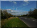
7
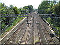
West Coast Main Line railway near Hemel Hempstead
Viewed looking south from the footbridge next to the Featherbed Lane road bridge.
Image: © Nigel Cox
Taken: 31 May 2009
0.15 miles
9
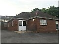
Plymouth Brethren Church, West Valley Road
Image: © Bryn Holmes
Taken: 6 Jul 2017
0.17 miles