IMAGES TAKEN NEAR TO
Maylands Avenue, HEMEL HEMPSTEAD, HP2 7TG
Introduction
This page details the photographs taken nearby to Maylands Avenue, HP2 7TG by members of the Geograph project.
The Geograph project started in 2005 with the aim of publishing, organising and preserving representative images for every square kilometre of Great Britain, Ireland and the Isle of Man.

There are currently over 7.5m images from over14,400 individuals and you can help contribute to the project by visiting https://www.geograph.org.uk
Image Map
Images are licensed for reuse under creativecommons.org/licenses/by-sa/2.0
Notes
- Clicking on the map will re-center to the selected point.
- The higher the marker number, the further away the image location is from the centre of the postcode.
Image Listing (5 Images Found)
Images are licensed for reuse under creativecommons.org/licenses/by-sa/2.0
Image
Details
Distance
2
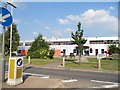
Industrial buildings on Maylands Avenue, Adeyfield
Image: © David Howard
Taken: 5 Sep 2013
0.11 miles
3
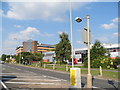
New offices on Maylands Avenue, Hemel Hempstead
Image: © David Howard
Taken: 23 Apr 2015
0.18 miles
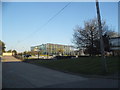
5
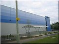
Mistral 260 in Maylands
Can't decide what the shelter in the foreground is intended to do. The bulk behind is a vast distribution warehouse built in 2005 by logistics developers, Gazeley.
Image: © Jack Hill
Taken: 20 Aug 2005
0.21 miles