IMAGES TAKEN NEAR TO
Three Cherry Trees Lane, HEMEL HEMPSTEAD, HP2 7PZ
Introduction
This page details the photographs taken nearby to Three Cherry Trees Lane, HP2 7PZ by members of the Geograph project.
The Geograph project started in 2005 with the aim of publishing, organising and preserving representative images for every square kilometre of Great Britain, Ireland and the Isle of Man.

There are currently over 7.5m images from over14,400 individuals and you can help contribute to the project by visiting https://www.geograph.org.uk
Image Map (Loading...)


Getting Data...Please wait
Leaflet Map data © OpenStreetMap
Images are licensed for reuse under creativecommons.org/licenses/by-sa/2.0
Notes
- Clicking on the map will re-center to the selected point.
- The higher the marker number, the further away the image location is from the centre of the postcode.
Image Listing (12 Images Found)
Images are licensed for reuse under creativecommons.org/licenses/by-sa/2.0
Image
Details
Distance
1
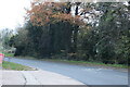
Three Cherry Trees Lane, Hemel Hempstead
Here is the same location in 2013 https://www.geograph.org.uk/photo/3638063
Image: © David Howard
Taken: 19 Nov 2022
0.09 miles
2
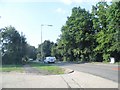
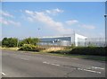
Three Cherrytrees Lane, Cupid Green
The industrial estate is out of sight on the left
Image: © David Howard
Taken: 5 Sep 2013
0.09 miles
3
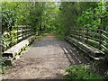
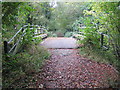
Nickey Line
Nickey Line on the original railway bridge over Three Cherry Trees Lane
Image: © Shaun Ferguson
Taken: 30 Apr 2010
0.18 miles
5
Industrial buildings by Swallowdale Lane
Image: © David Howard
Taken: 5 Sep 2013
0.18 miles
6
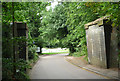
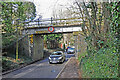
Hemel Hempstead: The Nicky Line
The trackbed of the dismantled Hemel Hempstead to Harpenden railway (The Nicky Line) viewed looking across the bridge over Three Cherry Trees Lane. The route is now a footpath and is also one of the few opened sections of the proposed National Cycle Network Route 57 that will eventually run from Cricklade in Wiltshire to Welwyn Garden City in Hertfordshire.
Update July 2011
A correspondent writes that the old original bridge abutments are collapsing so the lightweight crossing seen here has been removed. Please see Image and Image
Image: © Nigel Cox
Taken: 14 Oct 2007
0.19 miles
7
Bridge on Three Cherry Trees lane removed
The bridge carrying the cycle track (formerly the Nickey Line Railway) has been removed as its substructure is collapsing.
Image: © Tom Presland
Taken: 23 Jul 2011
0.19 miles
8
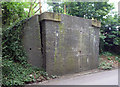
Collapsing Bridge support
The sides of this mid Nineteenth Century railway bridge are collapsing. The lightweight cycleway bridge shown in http://www.geograph.org.uk/photo/585262 has been removed.
Image: © Tom Presland
Taken: 23 Jul 2011
0.19 miles
9
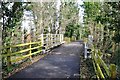
Resurfaced Nickey Line path
The resurfaced path over the reinstated bridge over Three Cherry Trees Lane. The bridge had previously been removed because its abutments were collapsing. They have now been repaired and the bridge deck reinstated.
Image: © Bob Walters
Taken: 24 Mar 2023
0.19 miles
10
Nickey Line bridge
The 'Nickey Line' trail bridge over Three Cherry Trees Lane has been repaired and the pathway above resurfaced.
Image: © Bob Walters
Taken: 24 Mar 2023
0.20 miles