IMAGES TAKEN NEAR TO
Swallowdale Lane, HEMEL HEMPSTEAD, HP2 7FZ
Introduction
This page details the photographs taken nearby to Swallowdale Lane, HP2 7FZ by members of the Geograph project.
The Geograph project started in 2005 with the aim of publishing, organising and preserving representative images for every square kilometre of Great Britain, Ireland and the Isle of Man.

There are currently over 7.5m images from over14,400 individuals and you can help contribute to the project by visiting https://www.geograph.org.uk
Image Map
Images are licensed for reuse under creativecommons.org/licenses/by-sa/2.0
Notes
- Clicking on the map will re-center to the selected point.
- The higher the marker number, the further away the image location is from the centre of the postcode.
Image Listing (13 Images Found)
Images are licensed for reuse under creativecommons.org/licenses/by-sa/2.0
Image
Details
Distance
1
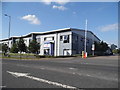
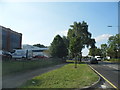
Screwfix on Maylands Avenue, Hemel Hempstead
Image: © David Howard
Taken: 13 Jul 2017
0.10 miles
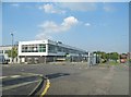
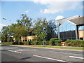
3
Industrial buildings by Swallowdale Lane
Image: © David Howard
Taken: 5 Sep 2013
0.12 miles

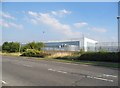
5
Maylands Avenue, Cupid Green
In the middle of the industrial estate
Image: © David Howard
Taken: 5 Sep 2013
0.18 miles
7
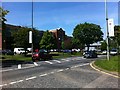
Maylands Avenue at the intersection with Eaton Road
Image: © Darrin Antrobus
Taken: 5 Jun 2013
0.20 miles

9
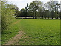
Nickey Line
Nickey Line nearing Redbourn Road. This part of the former Hemel Hempstead to Harpenden railway line has been lost completely to factories.
Image: © Shaun Ferguson
Taken: 30 Apr 2010
0.23 miles