IMAGES TAKEN NEAR TO
Tannsfield Drive, HEMEL HEMPSTEAD, HP2 5LG
Introduction
This page details the photographs taken nearby to Tannsfield Drive, HP2 5LG by members of the Geograph project.
The Geograph project started in 2005 with the aim of publishing, organising and preserving representative images for every square kilometre of Great Britain, Ireland and the Isle of Man.

There are currently over 7.5m images from over14,400 individuals and you can help contribute to the project by visiting https://www.geograph.org.uk
Image Map
Images are licensed for reuse under creativecommons.org/licenses/by-sa/2.0
Notes
- Clicking on the map will re-center to the selected point.
- The higher the marker number, the further away the image location is from the centre of the postcode.
Image Listing (5 Images Found)
Images are licensed for reuse under creativecommons.org/licenses/by-sa/2.0
Image
Details
Distance
1
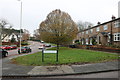
Uranus Road at the corner of Jupiter Drive
Yes there is a theme here.
Image: © David Howard
Taken: 23 Nov 2019
0.15 miles
2
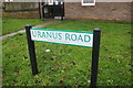
Sign for Uranus Road, Hemel Hempstead
The area has roads named after planets and satellites.
Image: © David Howard
Taken: 23 Nov 2019
0.18 miles
5
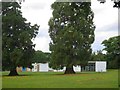
Jupiter Drive Junior School off Queensway Hemel Hempstead
This school is opposite the speed camera in Queensway
Image: © Jack Hill
Taken: 25 Aug 2005
0.21 miles