IMAGES TAKEN NEAR TO
Alexandra Road, HEMEL HEMPSTEAD, HP2 5BE
Introduction
This page details the photographs taken nearby to Alexandra Road, HP2 5BE by members of the Geograph project.
The Geograph project started in 2005 with the aim of publishing, organising and preserving representative images for every square kilometre of Great Britain, Ireland and the Isle of Man.

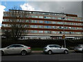
There are currently over 7.5m images from over14,400 individuals and you can help contribute to the project by visiting https://www.geograph.org.uk
Image Map
Images are licensed for reuse under creativecommons.org/licenses/by-sa/2.0
Notes
- Clicking on the map will re-center to the selected point.
- The higher the marker number, the further away the image location is from the centre of the postcode.
Image Listing (88 Images Found)
Images are licensed for reuse under creativecommons.org/licenses/by-sa/2.0
Image
Details
Distance
2
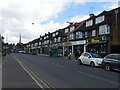
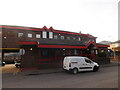
Shops, Marlowes (near to Gadebridge Park)
Image: © Bryn Holmes
Taken: 12 Apr 2021
0.07 miles
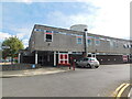
3
New West Herts College building, Marlowes
Image: © Bryn Holmes
Taken: 12 Apr 2021
0.08 miles
4
The Greek Restaurant, Hemel Hempstead
Modern use for a Georgian building in central Hemel Hempstead.
http://www.dacorum.gov.uk/
Image: © Colin Smith
Taken: 27 Sep 2009
0.08 miles
5
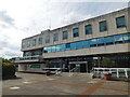
Hemel Hempstead Civic Centre
This was the building that housed the borough council, as well as other services relating to the council. It was closed in 2017, with the council moving to the nearby Forum, and has now been demolished, to be replaced with apartments.
Image: © Bryn Holmes
Taken: 6 Sep 2015
0.09 miles
6
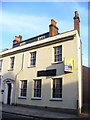
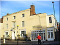
Old Hempstead House
Georgian mansion house facing the foot of Hemel Hempstead's High Street. Today it is an office block, seeking a new occupier.
http://www.dacorum.gov.uk/
Image: © Colin Smith
Taken: 27 Sep 2009
0.10 miles
7
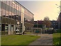
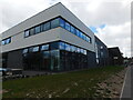
West Herts College
Dacorum campus's main teaching block.
Image: © Graham Hale
Taken: 11 Apr 2011
0.10 miles
8
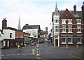
Hemel Hempstead: High Street
This is the southern end of the High Street viewed looking across Queensway from Alexandra Road, with the landmarks, from left to right, of the steeple of St Mary's Church, the tower of the old Town Hall, and the Victorian Gothic steeple of the corner building currently used by ALH Insurance.
The 1940s Ordnance Survey map shows this road junction to be the most important in Hemel with the A4146 road heading south to the left and the A4147 road heading east leaving the junction to go up Alexandra Road towards Hemel Hempstead Midland railway station.
Image: © Nigel Cox
Taken: 14 Oct 2007
0.10 miles
9
Fernville Surgery
General practice (GP) in Hemel Hempstead town centre.
Image: © Bryn Holmes
Taken: 16 Feb 2016
0.11 miles
10
Hemel Hempstead Fire Station, Queensway
Image: © Bryn Holmes
Taken: 6 Sep 2015
0.11 miles