IMAGES TAKEN NEAR TO
The Coppice, Wood Lane End, HEMEL HEMPSTEAD, HP2 4TB
Introduction
This page details the photographs taken nearby to The Coppice, Wood Lane End, HP2 4TB by members of the Geograph project.
The Geograph project started in 2005 with the aim of publishing, organising and preserving representative images for every square kilometre of Great Britain, Ireland and the Isle of Man.

There are currently over 7.5m images from over14,400 individuals and you can help contribute to the project by visiting https://www.geograph.org.uk
Image Map
Images are licensed for reuse under creativecommons.org/licenses/by-sa/2.0
Notes
- Clicking on the map will re-center to the selected point.
- The higher the marker number, the further away the image location is from the centre of the postcode.
Image Listing (6 Images Found)
Images are licensed for reuse under creativecommons.org/licenses/by-sa/2.0
Image
Details
Distance
1
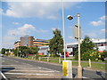
Industrial buildings on Maylands Avenue, Adeyfield
Image: © David Howard
Taken: 5 Sep 2013
0.09 miles
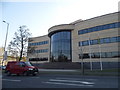
4
New offices on Maylands Avenue, Hemel Hempstead
Image: © David Howard
Taken: 23 Apr 2015
0.15 miles
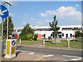
5
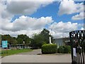
Adeyfield School Hemel Hempstead
The school classrooms are set well back from a busy road.
Image: © Jack Hill
Taken: 25 Aug 2005
0.23 miles
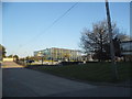
6
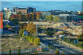
Hemel Hempstead : Maylands Avenue
Looking towards Maylands Avenue and beyond.
Image: © Lewis Clarke
Taken: 3 Oct 2018
0.24 miles