IMAGES TAKEN NEAR TO
St. Margarets Way, HEMEL HEMPSTEAD, HP2 4PA
Introduction
This page details the photographs taken nearby to St. Margarets Way, HP2 4PA by members of the Geograph project.
The Geograph project started in 2005 with the aim of publishing, organising and preserving representative images for every square kilometre of Great Britain, Ireland and the Isle of Man.

There are currently over 7.5m images from over14,400 individuals and you can help contribute to the project by visiting https://www.geograph.org.uk
Image Map
Images are licensed for reuse under creativecommons.org/licenses/by-sa/2.0
Notes
- Clicking on the map will re-center to the selected point.
- The higher the marker number, the further away the image location is from the centre of the postcode.
Image Listing (13 Images Found)
Images are licensed for reuse under creativecommons.org/licenses/by-sa/2.0
Image
Details
Distance
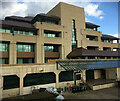
2
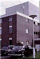
Post House Hotel
Hemel Hempstead, just off M1 in 1972
Image: © Stanley Howe
Taken: 16 May 1972
0.14 miles
3
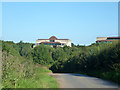
Breakspear Park over the trees
Part of this very large office complex viewed from Westwick Row.
Image: © Robin Webster
Taken: 6 Sep 2015
0.17 miles
4
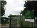
Leverstock Green Primary School
Interesting to see the "Tiny Tots" sign as well
Image: © Jack Hill
Taken: 20 Aug 2005
0.18 miles
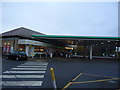
8
Hemel Hempstead : Breakspear Way A414
Looking along Breakspear Way.
Image: © Lewis Clarke
Taken: 3 Oct 2018
0.22 miles