IMAGES TAKEN NEAR TO
Longlands, HEMEL HEMPSTEAD, HP2 4DE
Introduction
This page details the photographs taken nearby to Longlands, HP2 4DE by members of the Geograph project.
The Geograph project started in 2005 with the aim of publishing, organising and preserving representative images for every square kilometre of Great Britain, Ireland and the Isle of Man.

There are currently over 7.5m images from over14,400 individuals and you can help contribute to the project by visiting https://www.geograph.org.uk
Image Map
Images are licensed for reuse under creativecommons.org/licenses/by-sa/2.0
Notes
- Clicking on the map will re-center to the selected point.
- The higher the marker number, the further away the image location is from the centre of the postcode.
Image Listing (13 Images Found)
Images are licensed for reuse under creativecommons.org/licenses/by-sa/2.0
Image
Details
Distance
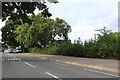
2
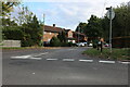
Windmill Road at the junction of White Hart Road
Image: © David Howard
Taken: 23 Nov 2019
0.16 miles
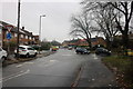
3
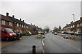
Adeyfield: Tenzing Road
Adeyfield was the first of Hemel Hempstead New Town's neighbourhoods to be developed, with construction starting around 1952. This road and its estate neighbours, Everest Way and Hillary Road, would have been named after the successful Everest summit-topping expedition team of May 1953. The denizens of Tenzing Road can sleep in their beds safe in the knowledge that Streetmap tells us that this is the only Tenzing Road in the country. Dacorum Borough Council have replaced most of the original road name plates in their area recently, so the one at the foot of the lamppost on the left here, with its faded gold letters on a blue background, is very much a survivor of an earlier time.
Tenzing Norgay, or Sherpa Tenzing, died at the age of about 71 in 1986.
Image: © Nigel Cox
Taken: 12 Apr 2009
0.16 miles
4
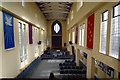
St Barnabas Church, Adeyfield: Interior view
The inside of St Barnabas church, seen from the gallery at the west end.
Image: © John Webb
Taken: 9 Feb 2015
0.16 miles
5
Windmill Road at the junction of White Hart Road
Image: © David Howard
Taken: 23 Nov 2019
0.16 miles
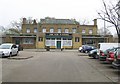
7
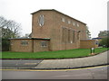
Adeyfield: St Barnabas Church
Photographed on Easter Sunday with the congregation in good voice, the foundation stone of the church was laid by Queen Elizabeth II on 20 July 1952. The Church's website is here http://www.stb-hemel.info/index.htm
Image: © Nigel Cox
Taken: 12 Apr 2009
0.17 miles
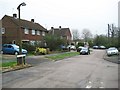
9
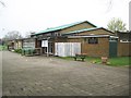
Adeyfield Community Centre
Adeyfield was the first of Hemel Hempstead New Town's eight neighbourhoods to be developed. This is the Community Centre in The Queen's Square.
Image: © Nigel Cox
Taken: 12 Apr 2009
0.19 miles
10
Adeyfield: The New Venture
Public house in The Queen's Square contemporary with the rest of the buildings in the neighbourhood.
Image: © Nigel Cox
Taken: 12 Apr 2009
0.19 miles