IMAGES TAKEN NEAR TO
Mary Cross Close, TRING, HP23 6QL
Introduction
This page details the photographs taken nearby to Mary Cross Close, HP23 6QL by members of the Geograph project.
The Geograph project started in 2005 with the aim of publishing, organising and preserving representative images for every square kilometre of Great Britain, Ireland and the Isle of Man.

There are currently over 7.5m images from over14,400 individuals and you can help contribute to the project by visiting https://www.geograph.org.uk
Image Map (Loading...)


Getting Data...Please wait
Leaflet Map data © OpenStreetMap
Images are licensed for reuse under creativecommons.org/licenses/by-sa/2.0
Notes
- Clicking on the map will re-center to the selected point.
- The higher the marker number, the further away the image location is from the centre of the postcode.
Image Listing (29 Images Found)
Images are licensed for reuse under creativecommons.org/licenses/by-sa/2.0
Image
Details
Distance
1
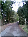
Highfield Road
A private road on the edge of Wigginton.
Image: © Burgess Von Thunen
Taken: 27 Jul 2010
0.07 miles
2
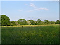
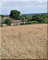
Meadow near Wigginton
A meadow full of buttercups and clover with may blossom still showing in the hedgerow.
Image: © Cathy Cox
Taken: 7 Jun 2006
0.13 miles
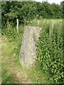
3
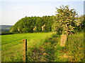
OS Triangulation Pillar at Wigginton
At 216 metres above sea level, but with fine views to the north only, this trig pillar is on the Ridgeway walk. Langton Wood is at the end of the field.
Image: © Nigel Cox
Taken: 7 Jun 2006
0.15 miles
4
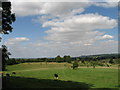
Tring Park
Tring Park originally formed part of the estate of the banker Lionel de Rothschild and of his son Nathaniel (1st Baron Rothschild of Tring), who made sweeping changes to the mansion, to the estate farms and its other buildings, and who opened the Tring Zoological Museum as a gift to his son Walter - the Museum now forms part of 'The Natural History Museum' (and is well worth a visit). Walter Rothschild was responsible for introducing numerous exotic animals - including wallabies, cassowaries, quaggas and rheas - into the Park's extensive grassland. Today the Park, which is managed by the Woodland Trust, is home to much less exotic sheep and cattle. This view is towards Pitstone Hill (skyline, right of centre).
Image: © Gerald Massey
Taken: 18 Aug 2009
0.17 miles
5
View from rear of Highfield Lodge, Wigginton
Looking across a field with plenty of wild flowers past the tops of a few houses on Osborne Way. In the distance the white tower than can just be seen is the top of Image] about 3½ miles (5½km) away.
Image: © Rob Farrow
Taken: 9 Jul 2023
0.17 miles
6
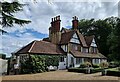
Wigginton - Highfield Lodge
This house bordering Tring Park at the end of dead-end drive in Wigginton is called Highfield Lodge. They had a garden open day, when these photos were taken. The house also offers Bed & Breakfast on Booking.com
On the large scale OS maps it is named as Ranger's Cottage. I would say that it dates from the last decades of the C19th.
Image: © Rob Farrow
Taken: 9 Jul 2023
0.17 miles
7
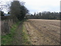
The Ridgeway
The Ridgeway by the Trig Point at Wigginton
Image: © Shaun Ferguson
Taken: 4 Jan 2013
0.17 miles
8
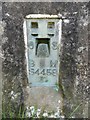
Flush Bracket Bench Mark on Triangulation Pillar near Wigginton
This photo shows the flush bracket benchmark on the triangulation pillar east of Fox Road near Wigginton. It has the letters OS (Ordnance Survey), BM (Bench mark) and its number S4458.
Image: © David Hillas
Taken: 20 Aug 2020
0.18 miles
9
Triangulation Pillar near Wigginton
This concrete pillar is located on The Ridgeway trail east of Fox Road, the postcode being HP23 6EE. Its height above sea level is 710 feet (216 metres). From this point, views can be obtained looking northeast towards the Ashridge Estate and Dunstable Downs. Its benchmark is on the right side of the pillar, https://www.geograph.org.uk/photo/6576084 refers.
Image: © David Hillas
Taken: 20 Aug 2020
0.18 miles
10
Trig pillar near Langton Wood north of Wigginton
This trig pillar is situated immediately adjacent to the Ridgeway path as it crosses between Fox Road and The Twist near to Langton Wood north of the village of Wigginton. For some strange reason this trig pillar with the flush bracket code of S4458 is referred to on the web as "Dunsley Farm" - which it is nowhere near ! (Dunsley Farm is on the outskirts of Tring nearly a kilometre away and 70m lower in altitude). The pillar marks a height of 216m (708')
Image: © Rob Farrow
Taken: 21 Jul 2012
0.18 miles