IMAGES TAKEN NEAR TO
Cholesbury Lane, TRING, HP23 6NF
Introduction
This page details the photographs taken nearby to Cholesbury Lane, HP23 6NF by members of the Geograph project.
The Geograph project started in 2005 with the aim of publishing, organising and preserving representative images for every square kilometre of Great Britain, Ireland and the Isle of Man.

There are currently over 7.5m images from over14,400 individuals and you can help contribute to the project by visiting https://www.geograph.org.uk
Image Map (Loading...)


Getting Data...Please wait
Leaflet Map data © OpenStreetMap
Images are licensed for reuse under creativecommons.org/licenses/by-sa/2.0
Notes
- Clicking on the map will re-center to the selected point.
- The higher the marker number, the further away the image location is from the centre of the postcode.
Image Listing (62 Images Found)
Images are licensed for reuse under creativecommons.org/licenses/by-sa/2.0
Image
Details
Distance
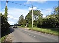
2
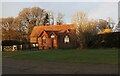
Sandpit Hill Cottages on Cholesbury Lane
Image: © David Howard
Taken: 27 Jan 2019
0.04 miles
5

Forget-me-nots (Myosotis genus), Cholesbury
This luxuriant clump of Forget-me-nots (of the Myosotis genus, probably Myosotis sylvatica, the Wood Forget-me-not) were growing on the eastern bank of the inner rampart of Cholesbury Iron Age Fort near to the pathway to Image]
Image: © Rob Farrow
Taken: 28 Apr 2024
0.07 miles
6
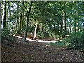
Cholesbury Camp (1) - Shallow external ditch at SW
The remains of the outer of the two ditches of the earthworks at Cholesbury Camp is much shallower and wider (and less well preserved) than the internal one. This view is from just off the Image] at the start of the circuit (clockwise).
Next image Image]
Image: © Rob Farrow
Taken: 29 Sep 2013
0.08 miles
8
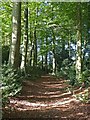
Cholesbury Camp (2) - Outer ditch western side
Most of the remaining earthworks at Cholesbury Camp are the inner ditch of the original multivallate structure, but on the western side of the oval a second outer ditch, seen here, is still obvious though not as well defined as the inner ditch. This view is taken a little further north than Image]
Next image in sequence Image]
Image: © Rob Farrow
Taken: 29 Sep 2013
0.09 miles
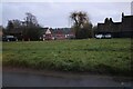
9
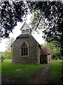
Cholesbury - Church of St Lawrence within iron age fort
The church of St Lawrence in the village of Cholesbury is unusual in that it is within the confines of an Iron Age hillfort; it is one of only two such situated churches in the Chilterns, the other being at West Wycombe.
Though originally dating from the C13th, almost everything seen today dates from its C19th reconstruction. It is EH Grade II listed: https://historicengland.org.uk/listing/the-list/list-entry/1332512?section=official-list-entry
Image: © Rob Farrow
Taken: 28 Apr 2024
0.09 miles