IMAGES TAKEN NEAR TO
Shire Lane, TRING, HP23 6LY
Introduction
This page details the photographs taken nearby to Shire Lane, HP23 6LY by members of the Geograph project.
The Geograph project started in 2005 with the aim of publishing, organising and preserving representative images for every square kilometre of Great Britain, Ireland and the Isle of Man.

There are currently over 7.5m images from over14,400 individuals and you can help contribute to the project by visiting https://www.geograph.org.uk
Image Map
Images are licensed for reuse under creativecommons.org/licenses/by-sa/2.0
Notes
- Clicking on the map will re-center to the selected point.
- The higher the marker number, the further away the image location is from the centre of the postcode.
Image Listing (6 Images Found)
Images are licensed for reuse under creativecommons.org/licenses/by-sa/2.0
Image
Details
Distance
1
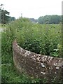
Curved Wall, Longcroft
This curved wall is opposite Longcroft Farm on Shire Lane and curves round into Image The building just visible in the background is Drayton Wood House (SP91860827)
Image: © Rob Farrow
Taken: 12 Jun 2007
0.02 miles
2
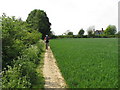
Path by Longcroft
Public footpath at the edge of a growing crop.
Image: © David Hawgood
Taken: 1 May 2011
0.03 miles
3
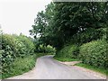
Shire Lane past Longcroft
Longcroft is immediately to the right here, with the entrance to Longcroft farm visible just ahead. The track leaving to the left at the bottom of the picture is Image] on the opposite side of its entrance to Image]
Image: © Rob Farrow
Taken: 12 Jun 2007
0.03 miles
4
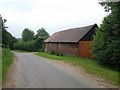
Oakengrove
Oakengrove is a property, probably a farm, on Shire Lane near Hastoe. The little white sign on the wall next to the close-board fence confirms this.
The main property stands a little way off the road, these being just some outbuildings.
Image: © Rob Farrow
Taken: 12 Jun 2007
0.09 miles
5
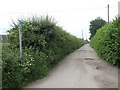
Bridleway to Leylands Farm
This bridleway leads off from opposite Longcroft on Shire Lane and continues past a Pig Farm and some other properties finally reaching Leylands Farm (see Image]) at the next lane to the west.
Image: © Rob Farrow
Taken: 12 Jun 2007
0.09 miles