IMAGES TAKEN NEAR TO
Church Lane, TRING, HP23 6LU
Introduction
This page details the photographs taken nearby to Church Lane, HP23 6LU by members of the Geograph project.
The Geograph project started in 2005 with the aim of publishing, organising and preserving representative images for every square kilometre of Great Britain, Ireland and the Isle of Man.

There are currently over 7.5m images from over14,400 individuals and you can help contribute to the project by visiting https://www.geograph.org.uk
Image Map (Loading...)


Getting Data...Please wait
Leaflet Map data © OpenStreetMap
Images are licensed for reuse under creativecommons.org/licenses/by-sa/2.0
Notes
- Clicking on the map will re-center to the selected point.
- The higher the marker number, the further away the image location is from the centre of the postcode.
Image Listing (22 Images Found)
Images are licensed for reuse under creativecommons.org/licenses/by-sa/2.0
Image
Details
Distance
1
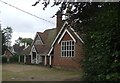
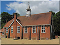
Hastoe Village Hall - Front
The front of Hastoe Village Hall, as seen from the entrance to its car park.
See shared description below for more information.
Image: © Rob Farrow
Taken: 13 Aug 2011
0.02 miles
2
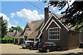
Hastoe Village Hall after Refurbishment
Same view a few years earlier Image
Image: © Chris Reynolds
Taken: 6 Jun 2015
0.02 miles
3
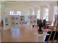
The Bucks Open Studios Exhibition in Hastoe Village Hall
Bucks Open Studios is an annual event which allows local artists to display their works. It also includes an number of studios and halls in the Tring area.
The picture shows the interior of the recently refurbished village hall, taken from the stage.
See also Image
Image: © Chris Reynolds
Taken: 6 Jun 2015
0.02 miles
4

The Bucks Open Studios Exhibition in Hastoe Village Hall
See also Image
Image: © Chris Reynolds
Taken: 6 Jun 2015
0.02 miles
5
Hastoe Village Hall - rear view
There are plans for the overgrown grounds at the rear of the village hall to become a car park for the users of the hall once it has been fully refurbished.
Please look at the shared description below for more information.
Image: © Rob Farrow
Taken: 13 Aug 2011
0.02 miles
6
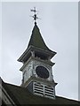
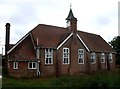
Hastoe Village Hall - Clock tower and belfry
This attractive little clock tower sits atop Hastoe Village Hall. Plans are afoot to fully restore the hall, including the clock seen here.
For more information about Hastoe Village Hall, see the shared description below.
Image: © Rob Farrow
Taken: 13 Aug 2011
0.02 miles
7
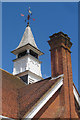
The Clock Tower on Hastoe Hall
See also view from different angle before refurbishment Image
Image: © Chris Reynolds
Taken: 6 Jun 2015
0.02 miles
8
The rear of Hastoe Village Hall
A similar view before refurbishment Image
Image: © Chris Reynolds
Taken: 6 Jun 2015
0.02 miles
9

Marlin Hill Farm at Hastoe Cross
Marlin Hill Farm nestles in a slight depression near the top of the eponymous hill at Hastoe Cross.
The track that this photo is taken from is marked on most of the OS maps as being The Ridgeway LDP, however the little waymark signs say that this is now simply a public footpath and permissive bridleway, while The Ridgeway is now signed as taking the more northerly route through Bishop's Wood, marked on the maps as part of the Icknield Way Trail LDP.
Image: © Rob Farrow
Taken: 28 Dec 2014
0.10 miles
10
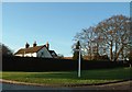
Marlin Hill Farm, Hastoe Cross
This farm is situated on the Ridgeway long distance path just outside the hamlet of Hastoe at Hastoe Cross.
Image: © Rob Farrow
Taken: 10 Dec 2005
0.12 miles