IMAGES TAKEN NEAR TO
Dunsley Place, London Road, TRING, HP23 6JL
Introduction
This page details the photographs taken nearby to Dunsley Place, London Road, HP23 6JL by members of the Geograph project.
The Geograph project started in 2005 with the aim of publishing, organising and preserving representative images for every square kilometre of Great Britain, Ireland and the Isle of Man.

There are currently over 7.5m images from over14,400 individuals and you can help contribute to the project by visiting https://www.geograph.org.uk
Image Map
Images are licensed for reuse under creativecommons.org/licenses/by-sa/2.0
Notes
- Clicking on the map will re-center to the selected point.
- The higher the marker number, the further away the image location is from the centre of the postcode.
Image Listing (570 Images Found)
Images are licensed for reuse under creativecommons.org/licenses/by-sa/2.0
Image
Details
Distance
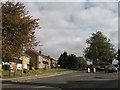
1
Houses at Dunsley Place, Tring, hiding behind the old Estate Wall
When the Rothschilds moved into Tring Mansion they started to improve the town, and the area adjacent to their house – and all the old houses in Lower Dunsley were demolished to make the gardens. In the late 20th century a small group of houses where built there, called Dunsley Place,
The picture is taken from Pound Meadow.
Image: © Chris Reynolds
Taken: 26 Apr 2009
0.01 miles
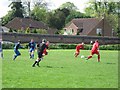
2

View across Pound Meadow in The Grey
A white sheet of snow covers Pound Meadow, a common field on the eastern side of Tring with football pitches that is often the venue for visiting fayres. Beyond can be seen some of the comparatively new houses at the western end of London Road and behind them some of the trees in the Memorial Garden.
The overwhelming greyness obscures most details, but more can be seen by viewing the larger images available by clicking "More sizes"
Image: © Rob Farrow
Taken: 5 Feb 2012
0.01 miles
4
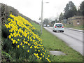
Daffodils in London Road, Tring
These were planted some years ago and are now well established.
See also Image
Image: © Chris Reynolds
Taken: 19 Mar 2016
0.02 miles
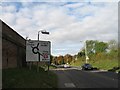
6
The Junction of London and Station Roads, Tring
Image: © Gerald Massey
Taken: 26 Oct 2009
0.03 miles
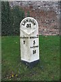
7
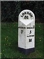
Old Milepost by the B4635, London Road, Tring Parish
Cast iron post by the B4635, (was A4251 and A41), in parish of TRING (DACORUM District), London Road, on the verge, on South side of road, by entrance to Dunsley Place. Sparrows Herne Casting, erected by the Sparrows Herne turnpike trust in the 19th century.
Inscription reads:-
: AYLESBURY / 7 : : LONDON / 31 : : BERKHAM-SD / 5 / WATFORD / 16 :
Grade II listed.
List Entry Number: 1078037 https://historicengland.org.uk/listing/the-list/list-entry/1078037
Milestone Society National ID: HE_LCA31.
Image: © MW Hallett
Taken: 21 Oct 2002
0.03 miles
8
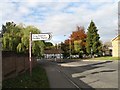
Sign Post, London Road, Tring
The sign post points to Station Road; the public house the background is the Robin Hood at the junction of Brook Street, London Road, and the Lower High Street.
See also . . . . Image; Image; Image; Image
Image: © Gerald Massey
Taken: 26 Oct 2009
0.04 miles
9
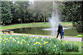
Daffodils in the Memorial Garden, Tring
The daffodils are here for Easter - as a father takes his son to see the nearly laid frog spawn
Image: © Chris Reynolds
Taken: 24 Mar 2016
0.05 miles
10
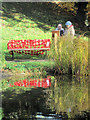
Reflecting on those who gave their lives in the Great War
After the Remembrance Service many people came to think of the significance of what had happened.
Each of the seats in the Memorial Garden was covered with a blanket of 116 poppies - one for each of the men who died.
In addition to the poppies there were notices giving details of individual soldiers.
Image
Image: © Chris Reynolds
Taken: 11 Nov 2018
0.05 miles