IMAGES TAKEN NEAR TO
Shootersway, TRING, HP23 6JA
Introduction
This page details the photographs taken nearby to Shootersway, HP23 6JA by members of the Geograph project.
The Geograph project started in 2005 with the aim of publishing, organising and preserving representative images for every square kilometre of Great Britain, Ireland and the Isle of Man.

There are currently over 7.5m images from over14,400 individuals and you can help contribute to the project by visiting https://www.geograph.org.uk
Image Map
Images are licensed for reuse under creativecommons.org/licenses/by-sa/2.0
Notes
- Clicking on the map will re-center to the selected point.
- The higher the marker number, the further away the image location is from the centre of the postcode.
Image Listing (7 Images Found)
Images are licensed for reuse under creativecommons.org/licenses/by-sa/2.0
Image
Details
Distance
1
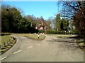
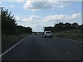
Road junction near Newsetts Wood
Taken from Shootersway Lane, to the right the lane leads to New Ground & Tring, to the left to Rossway. Straight ahead a track through Newsetts Wood leads to Champneys Health Resort.
Image: © Rob Farrow
Taken: 2 Mar 2006
0.03 miles
3
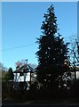
House near Tinkers lane
Taken from the crossroads where Hamberlins lane/Tinkers Lane crosses Rossway Lane. The dog on the weather vane is quite unusual.
Image: © Rob Farrow
Taken: 2 Mar 2006
0.09 miles
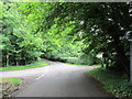
4
Snowdrop bedecked verge
Lane and verge with snowdrops at the Hamberlins/Tinkers Lane & Rossway Lane crossroads.
Image: © Rob Farrow
Taken: 2 Mar 2006
0.09 miles
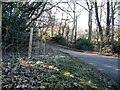
7
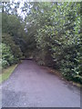
Champneys
Driveway to the east of the health spa.
Image: © Burgess Von Thunen
Taken: 27 Jul 2010
0.23 miles